The Skirrid Inn Llanvihangel Crucorney Pub Walk
Skirrid Fawr/Ysgyryd Fawr/Holy Mountain circular walk, 5 miles

You set off for Ysgyryd Fawr - the Skirrid - knowing you’re walking towards a mountain with a story to tell.
Its outline dominates the horizon near Abergavenny like a giant, jagged tooth. The mountain has a presence that gets under the skin as you approach the village, seen for miles across the patchwork of Monmouthshire fields. If you're coming from the east Skirrid Fawr marks the start of the Brecon Beacons National Park, or Bannau Brycheiniog as it's now known.
Awaiting you at the start/end of this pub walk is the Skirrid Mountain Inn in Llanvihangel Crucorney — a pub so bound to the hill that it added the word 'mountain' to its name to acknowledge the truth. Even the pub sign shows the mountain cracked by lightning, a nod to the story of the Skirrid.
This is the oldest pub in Wales, but that's not necessarily what it's famous for!
About The Skirrid Mountain Inn, Llanvihangel Crucorney
Last visit: April 2026
I swear that all kids in Welsh schools are taught that The Skirrid Inn is the oldest pub in Wales. It feels like something I've always known. Yet I can't imagine Mum & Dad telling me, so it must've been school!
Step inside and the legend immediately starts to validate itself. The studded oak door — carbon‑dated, they’ll tell you, to something like fifteen centuries old — swings open onto stone flags, low beams and a staircase pegged together with wooden dowels.
That staircase is the centre of the inn’s darker past. For generations, locals have said the upper floor once served as a courtroom, and that the condemned were hanged from a beam above the stairwell. Not wishing to miss a trick a hanging rope is still there, and scorch marks and rope grooves are pointed out with a kind of pride.
Sheep rustling seems to have been a local weakness. The numbers hung for it vary — 180 is the figure most often repeated. No official records of course, discounting the faux scrolls on the wall.
The Skirrid’s history seems to be a combination of the documented and the deeply believed.
William de Braose is said to have staged a Christmas‑time massacre here in 1175, inviting Welsh nobles to dine before having them cut down in revenge for an earlier killing.
Owain Glyndŵr’s supporters are said to have gathered here too, plotting raids and rebellion in the early 1400s.
Whether these stories are fact, embroidery or something in between, they speak to the inn’s long role as a place where power, fear and loyalty have rubbed shoulders.
And then there are the ghosts, which cling to the building as tenaciously as the history.
Fanny Price, the 17th‑century landlady who 'died of consumption' at thirty‑five, is the most frequently mentioned — a friendly presence, still keeping an eye on the place she once ran. Others are less comforting: footsteps on the stairs, glasses hurled from nowhere, cold spots that settle on the back of the neck.
For all its tales, the Skirrid Mountain Inn remains a working pub rather than a museum of itself. But like me, today's walkers & visitors seem to absorb themselves in the history of the place. You can't help it. If the mountain gives the pub its silhouette; the pub gives the mountain its reward.
Together they form one of those rare pairings where the landscape and the building feel like two chapters of the same story.


Pub Key Information
| WEBSITE | https://skirridinn.com/ |
| ADDRESS | Llanvihangel Crucorney, Abergavenny, NP7 8DH |
| PHONE | 01873 890258 |
| WHAT3WORDS | ///opera.mixes.digit |
| PARKING | Car park at the rear of the pub, through an archway. Street parking in the village too. |
| LOCATION | The village of Llanvihangel Crucorney is off the A465 Abergavenny to Hereford Road, about 3 miles outside Abergavenny. You can't miss the pub is on the road through the village. |
| HANDY FOR | Brecon Beacons national park. This area is walking gold. Beacons Way, Offas Dyke, Cambrian Way are in easy reach from here, as is Hatterall Hill and Llantony Priory, plus the 3 castles walk too. |
Walk Overview
The walk from the Skirrid Mountain Inn to Skirrid Fawr begins with the mountain already in full view, rising above the fields.
The path draws you steadily towards that great green scar, the fields falling away behind you as the ridge begins to dominate the sky.
It’s one of those rare walks where the destination is visible almost from the first step, yet the mountain keeps changing character as you approach.
And the story to tell? Locally known as Holy Mountain a popular legend tells how the dramatic landslide on the north of the mountain (the scar to the right) was caused by an earthquake or lightning strike at the moment of the crucifixion of Jesus!


Walk Instructions: Choose what works for you
There are multiple ways to consume the route described below.
- Either follow the online instructions, or download and print a copy of the route.
- If you have the OS Maps app, you can follow a saved route directly in the App.
- Or download the GPX file for use on your chosen GPS-based navigation application.

Walk Key Information
| START/FINISH | In the village of Llanvihangel Crucorney. You'll see the church along the only street. The walk starts by following a path downhill opposite it. |
| PARKING | Park at the pub, but there is street parking through the village if its busy. I was able to park on the roadside in front of the church. |
| GRID REFERNCE | SO 326 206 |
| WHAT3WORDS | ///opera.mixes.digit |
| DISTANCE/TIME | 5 miles / 8 km; approx 2.5 hours |
| ASCENT | 1263 feet / 390 metres |
| PATHS/TERRAIN | Quiet lanes, fields, and well-defined footpaths. Gates and stiles. I found some stiles to be unstable, in need of attention, so take care. Lots of sheep! |
| DIFFICULTY | It's an uphill out and a downhill back. If you tackle the hill head on it can be properly challenging & you might face an involuntary scramble to the right hand side as you approach. But there are options to suit all tastes, and I've suggested a pragmatic approach here. |
| PUBLIC TRANSPORT | Served by bus #23 that runs on the Abergavenny-Hereford route. |
| TOILETS | At the pub. |
| OTHER PUBS TO VISIT | Check opening times: The Llantony Priory, Llantony; The Hunters Moon Inn, Llangattock Lingoed. Both are excellent and worth visiting. The Crown Inn at Pantygelli also very good. Please try the Halfway at Tal-y-Coed: the embodiment of what a pub can deliver for tis community. |
Directions
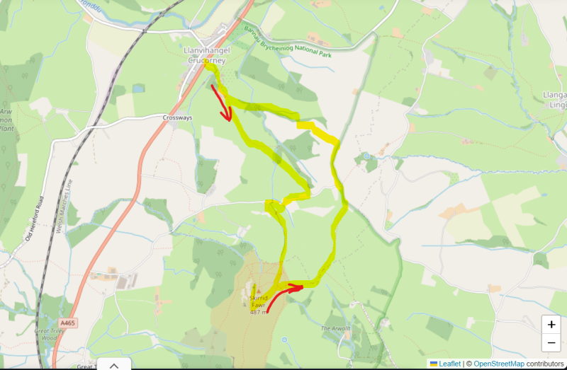
- Across the road from St Michael's Church in the village of Llanvihangel Crucorney a lane leads down to the main A465 road, which you need to cross.
- Join another lane straight ahead that leads towards Llanvihangel Court. It's open for tours on selected days: Guided tours in Summer and Christmas Fair - Llanvihangel Court. Follow the lane around the walls of the Court, rising uphill to pass a superb medieval barn. Watch out for peacocks in the grounds.
- Continue on this lane until you see footpath signs to the right leading into fields, and wonderful views of Skirrid Fawr.
- Signs guide your way upward through fields (of sheep) along fence boundaries, eventually crossing a field to a woodland, with a gate leading you into the woods. It's a short traverse before you emerge through another gate into the next field.
- From here, you bear right to continue to rise uphill through the next few fields. There were shetland ponies minding their own business here. Just stick with the direction of the footpath markers, but the goal is a gate into the next field and then top left of that field to the side of a house where a gate takes you through a hedge onto a lane.
- Turn right and continue until you pass a house called The Steppes. Its garden and parking for The Steppes is to the right of the house further up the lane, and the footpath leads up off the lane in front of its gate. There are some helpful signs to guide you.
- More fields to traverse from here as the steady uphill continues, all guided by footpath markers on the various gates and stiles.
- You're generally heading for the base to the left hand side of the Skirrid, and a gate out of the last field should deliver you there.
- There are options now. My recommendation is to continue along the path that continue straight ahead to the left hand side of the mountain. You'll soon see a route that cuts across the slope uphill, very well marked and manageable. Ignore others that appear to take a more direct route to the summit, unless you're the scrambling type.
- This path will deliver you to the ridge approx 100 metres below the summit. You'll immediately see that you need to turn right for the final approach to the trig point to celebrate your arrival at the top.
- The ridge is the main path up for those approaching from the Abergavenny direction. For the return, go back to where you joined it on the way up, a hundred metres or so back down the ridge.
- Retrace your steps down this path on the side of the Skirrid. Towards the bottom, instead of heading left, the direction you came from, continue straight ahead to cross into the field in front of you.
- The route guides you down the field to the fence/gate on the other side. To your left, take the stile into the field, now heading in the direction of the village. I found some of the stiles from here onwards quite fragile, so take care!
- You can follow the fence line up and over the brow, then head to the left to follow the fence line in front of you until you meets a gate. There's been a slight re-route of the marked path, but the gate into the next field is the logical exit from the field you're in.
- Follow the waymarked path downhill from here towards farm buildings. Pass through a series of gates to the left at the bottom, heading through the yard to join a lane.
- Turn left along the lane and continue straight ahead, ignoring the junction left at the hamlet of Pen-y-Parc. The next turn is a footpath to the left beyond the next house, opposite a pond.
- You're on the final run back towards Llanvihangel Court now. The path is marked but I got the sense that this area isn't walked as much as the outward route. Pass by a ruined house to cross into a field.
- Continue down the field and into the next one. Keep your eyes peeled for the footpath sign to the right. It takes you eventually onto a lane, and another gate gets you into the field on the other side of the lane.
- You follow the path downhill in the next field until a gate on your left in woodland, beyond a stream, leaves the fields to join an access lane where a giant oak has fallen some time ago.
- This is the lane that leads back past Llanvihangel Court, so continue to familiar ground for the return to the village.
Notes
The best pub walks are meant to be shared.
If you’ve followed this route, found a better path, got lost, uncovered a standout pint somewhere else, or simply have a story to tell, I’d be delighted to hear from you.
This site is as much about shared discoveries as it is about the walks themselves.
Add comment
Comments