The Pub: The Black Horse, Clapton-in-Gordano
The Walk: Clapton Circuit in the Gordano Valley, 3 miles

As the M5 heads south over the Avonmouth Bridge, most travellers clock Gordano Services without ever thinking about its name.
‘Gordano’ refers to the long, sheltered valley beneath the motorway — a landscape the road now passes over on its way to Clevedon.
Rather than pulling into the Services at Junction 19, slip off towards Portishead and wind your way to the quiet village of Clapton‑in‑Gordano just a few miles away.
Here you’ll find an easy, level leg‑stretcher that won’t trouble the lungs and can be done in an hour or so.
And at its heart, tucked away on the old road to Clevedon, sits the Black Horse: a glorious, time‑capsule of a pub, pouring beer straight from the cask (and serving food at lunchtimes only).
About The Black Horse
Last visited: March 2026
Quite simply, The Black Horse might be one of the finest pubs in the South West — and certainly one of the most unspoilt.
Locally known as the Kicker, it’s a genuine throwback, the sort of place where you can almost picture travellers from centuries past pausing for a pint and a story. Many of the original features remain, and the whole place feels wonderfully suspended in time.
In winter, a roaring fire dominates the main room, rifles hanging above like a nod to its past. There’s a snug for hiding away, and a separate back lounge with a pool table. Black‑and‑white photos of well‑known locals — and their dogs, naturally — line the walls.#
Beer comes straight from the barrel: usually Butcombe, alongside other local ales and ciders.
It’s a pub cherished by the village, but equally loved by walkers and cyclists who settle outside in the sunshine, where drinks are served through a hatch.
Clapton‑in‑Gordano itself dates back to the 1300s, and this walk takes you past some of the earliest village buildings — the Black Horse among them.
The pub name is thought to come from the area’s mining past: pit horses once worked the nearby seams, and others hauled coal down to Portishead’s docks. The pub even doubled as the local gaol, with the lounge window still barred as a reminder.
Food is served at lunchtimes only — simple rolls, ploughman’s, and a decent coffee.
So next time you’re on the M5 and tempted by Gordano Services at Junction 19, take the detour instead. The Kicker is a far better place to stretch your legs and lift your spirits.


Pub Key Information
| WEBSITE | https://www.theblackhorseclapton.co.uk/ |
| ADDRESS | Clevedon Lane, Clapton-in-Gordano, Portishead, BS20 7RH |
| PHONE | 01275 842105 |
| WHAT3WORDS | ///dynasties.coasting.wings |
| PARKING | Pub car park. Further parking underneath the M5 on a lane across from the pub. |
| LOCATION | The village is just outside Portishead, off the M5 at Junction 19 near Bristol. |
| HANDY FOR | The 'Gordano Round' is a figure-of-eight walk in this area, covering 26 miles. You'll see markers for it on some of the gates during this walk. |
Walk Overview
This short walk is known locally as the Clapton Circuit, a simple 3 mile route that provides a flavour of the Gordano Valley. More importantly, it very sensibly takes in The Black Horse which you cannot miss!
Initially following what would have been the old road between Portbury and Clevedon through Clapton-in-Gordano, the route soon leaves Clevedon Lane to head into fields in the direction of St Michael's Church.
This is a popular equestrian area so you'll see many horses on the way around, and some might be present in the fields that form a large part of this walk.
Gordano means 'muddy valley' in Old English, so if there's been a dash of rain or a heavy dew, expect wet shoes.
Generally, it's an easy walk that's reasonably well signposted. The sound of the M5 can be a distraction, but remember why you're here - The Black Horse is brilliant!


Walk Instructions: Choose what works for you
There are multiple ways to consume the route described below.
- Either follow the online instructions below, or download and print a copy of the route.
- If you have the OS Maps app, you can follow a saved route directly in the App.
- Or download the GPX file for use on your chosen GPS-based navigation application.

Walk Information
| START/FINISH | The Black Horse, Clevedon Lane, Clapton-in-Gordano, BS20 7RH |
| PARKING | Pub car park. Further parking underneath the M5 on a lane across from the pub. |
| GRID REFERENCE | ST 473 739 |
| WHAT3WORDS | ///dynasties.coasting.wings |
| DISTANCE / TIME | 3 miles / 5 km; approx 1 1/2 hours |
| ASCENT | 178 feet / 55 metres |
| PATHS/TERRAIN | Mainly fields, some shared with horses & sheep in Winter. Can be wet underfoot so muddy in places. Quite a few gates, & the odd stile. |
| DIFFICULTY | Easy. A few 'slopes' rather than hills. |
| PUBLIC TRANSPORT | Nothing through the village. Bus services run regularly to Portishead from Bristol (X4), and less frequently from Portishead towards Clevedon (X5, X10 services) along the B3124. There are footpaths that connect this B road across fields to the village, which would add a mile or so to the walk. |
| TOILETS | At the Black Horse |
| OTHER PUBS TO VISIT | Numerous pubs & bars in Portishead, such as The Ship, The Settle Inn, The Phoenix Bar and The Port. Towards Bristol, at Long Ashton are the much loved Miners Rest and The Angel Inn. Highly recommend seeking those pubs out if you have the time. |
Directions
- As you’re facing the front of the pub, go left up Clevedon Lane through the village, in the direction of Clevedon.
- You’re looking for a footpath off this lane on your left hand side. It’s slightly up the drive of Church Path Cottage, a wide driveway that serves a few houses on this left hand side at the end of the village (including one called Hillcrest further up the slope).
- The footpath runs to the side of the Church Path Cottage’s wooden fence/hedge, now slightly above Clevedon Lane. Don’t worry if you miss it – just follow the lane to pick up the path in the instructions below!

- Follow Clevedon Lane around a 90 degree bend. You’re in horse country here, and will be turning left into a farmyard path quite soon. A green footpath sign guides the way through the farm yard, with a large modern barn on your left hand side as you rise slightly uphill.
- Bear right just beyond this barn on a grassy path up to a gate into a field, which you might share with a few horses. The direction through the field is clearly marked, and often adjusted slightly as enclosures for horses are created with electric fencing. The path for walkers to and through various footpath gates across these fields are distinctly maintained.
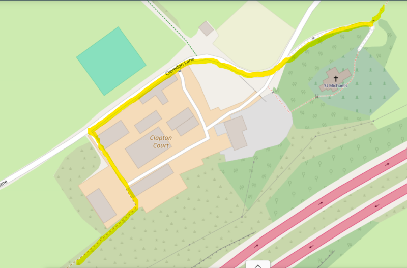
- You’ve gained height across the fields now to walk alongside a fence just below the M5. The path takes you back down hill in the next field alongside a coppice, on your left. You’ll see a gate at the far end of this field, and once through it, the path takes you back onto Clevedon Lane once again.
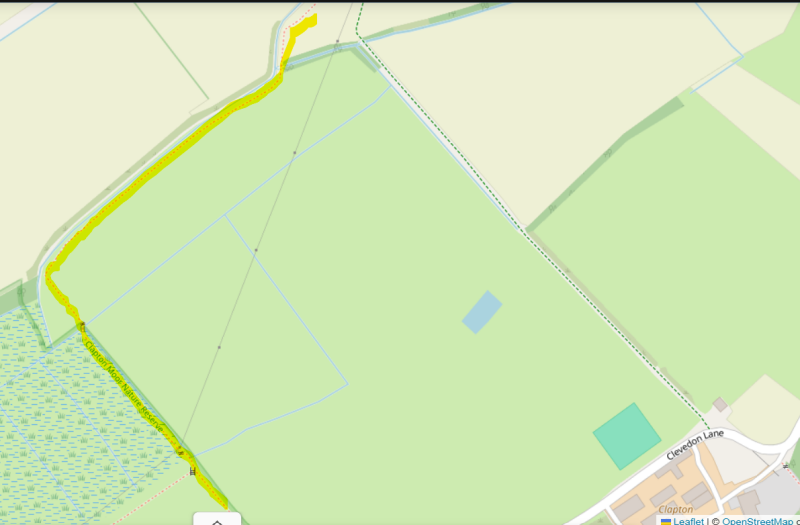
- Cross straight over the lane into the opposite field to pick up the footpath that now runs back in the direction of Clapton, alongside the hedge on this other side of Clevedon Lane. As you follow the field hedge line you’ll pass through a few gates, with footpath signage to confirm you’re in the right spot. If the Lane is the other side of the hedge you are!

- Continue until the end of the field, then bear left down the field where you exit via a gate into a short section of boggy Clapton Moor. It was dry-ish when I walked across this section, but will be damp after a wet spell no doubt.
- Continue to a footbridge into a field, again you’ll see it signposted. As you enter the field, go straight ahead to the edge of the drainage ditch, and then follow it to your right (see diagram), eventually onto Clapton Drove straight ahead.
- This is a muddy farm track that passes farm buildings and houses (Mayo Farm), and much used by horse riders from the nearby Sperrings Equestrian Centre.
- Along this lane you’re looking for a path through a gate into a field on your right. Ignore the first footpath sign opposite Mayo Farm until you see another one about 200 yards further up this lane. As a clue, as you look into the field you’ll see Clapton Farm on your left. Head into the field towards a small footbridge over a stream.
- You’ll be able to see the village of Clapton-in-Gordano in front of you as you walk through this field. Proceed to the top, passing a duck pond behind a hedge on your right.
- Leaving the field through a gate, bear right. You’ll soon cross into and through a yard of a private house (Myrtle Cottage) with a small stable block, before eventually emerging into the entrance to The Black Horse.
The best pub walks are meant to be shared.
If you’ve followed this route, found a better path, got lost, uncovered a standout pint somewhere else, or simply have a story to tell, I’d be delighted to hear from you.
This site is as much about shared discoveries as it is about the walks themselves.
Add comment
Comments