The Blue Flame Inn West End, Nailsea Pub Walk
An easy, enlightening circuit of Nailsea & West End, 3.5 miles

This largely level, lovely walk from The Blue Flame Inn at West End follows a generous stretch of the waymarked Nailsea Round. It threads together farmland, woodland paths, and a wander through the oldest part of Nailsea, with a glimpse of the town’s ever‑creeping residential edge.
Nailsea has been earmarked for major expansion — no doubt a boon for the Blue Flame — though you can’t help wondering how many of these fields will survive the next wave of development.
Highlights include Trinity Church, the beautifully restored Tithe Barn, and a quiet tribute to Hannah More, who opened a school here for the children of Nailsea’s colliers. A road in Nailsea now bears her name.
Hannah's name has kept turning up on my walks in Somerset. She deserves more than a road through a housing estate, so I've provided extra insight in a blog post, a commemoration to Hannah More: in the 1780s and 1790s, a handful of women with no vote, no public office, and no institutional backing managed to build schools, challenge exploitation, and try to lift whole communities out of ignorance and despair.
But the pub is the star of this West End show.
About The Blue Flame Inn, West End (near Nailsea)
Last visited: May 2026
Forget London’s glittering West End — the star of this south western end of Nailsea is a scruffy, glorious, time-warped pub.
From the outside, as you can see, it barely looks like a pub at all.
It looks like an old farmhouse that time quietly forgot — no hanging baskets groomed to within an inch of their lives, no glow of a flatscreen through the window, nothing to reassure the casual passer-by.
This is what a rural pub looked like when they first started handing out licenses, in the days before breweries decided they needed a brand. The Blue Flame Inn never got the memo, and thank god it never will.
Inside, CAMRA lists it as a pub interior of special national historic interest. Reviewers have called it “one of the last remaining authentic British pubs in existence” and “a rare gem — the absolute opposite of a corporate pubco.”
The original bar is a tiny room off the corridor, with faded nicotine walls and a roomful of lively conversation - a rough sea crossing to Lundy when I visited — the kind of atmosphere no interior designer could manufacture in a thousand years of trying.
In summer the garden comes alive with pizza, barbecues and outdoor music. In winter, conversation fills the small rooms just as warmly.
Superb beer and cider served straight from the barrel — the way it always should have been done. The gents, for those who need to know, are in an outside privy.
Here’s the thing about the Blue Flame: plenty of people will have driven past it on the quiet back lane around Nailsea, glanced over, and carried on. Maybe because it's a pub that other people - not you - go to.
But rural pubs don’t work like that anymore. They need our custom — not one day, but this day. So when you arrive after your walk, don’t hesitate, try the door. Go in. Order something. Stay a while.
Because if enough people do the opposite, one day you’ll drive past and it’ll have given way to the latest housing development on this side of Nailsea.
And you’ll remember that time you nearly went in to The Blue Flame Inn once.


Pub Key Information
| WEBSITE | https://www.facebook.com/TheBlueFlameInn |
| ADDRESS | The Blue Flame Inn, Netherton Wood Lane, West End, Nailsea, BS48 4DE |
| PHONE | 01275 856 910 |
| WHAT3WORDS | ///inflation.regress.globe |
| PARKING | In front of the pub, and a small car park at the rear. |
| LOCATION | The Blue Flame lies to the west of Clevedon, to the south of Nailsea in a hamlet called West End. Lots of residential building in this area, but West End and the Blue Flame continues to hold out. |
Walk Overview
West End is a quiet hamlet outside Nailsea, easily accessed from Clevedon and Backwell too. This walk crosses fields of crops, cows, and various sports, and provides insight into the expansion of the village of Nailsea on its march towards 'towndom'. But this is a wonderful community with an active Anglican church, Holy Trinity, its driving force visited on the way.
There's a short section through the newer residential areas before returning to open fields, with views over towards the iron age hill fort of Cadbury Camp, beyond the new 'ski lift' infrastructure pylons of the Hinkley Point C Nuclear development. An easy, level walk of contrasts.


Walk Instructions: Choose what works for you
There are multiple ways to consume the route described below.
- Either follow the online instructions, or download and print a copy of the route.
- If you have the OS Maps app, you can follow a saved route directly in the App.
- Or download the GPX file for use on your chosen GPS-based navigation application.

Walk Key Information
| START/FINISH | The Blue Flame Inn, Netherton Wood Lane, West End, Nailsea, BS48 4DE |
| PARKING | At the pub. |
| GRID REFERNCE | ST 448 690 |
| WHAT3WORDS | ///inflation.regress.globe |
| DISTANCE/TIME | 3.8 miles / 6 km; approx 1.5 hours |
| ASCENT | 160 feet / 50 metres |
| PATHS/TERRAIN | Country lanes, fields, woodland paths. Stiles and gates. Cattle in a few of the fields, but they were mostly disinterested. |
| DIFFICULTY | Easy |
| PUBLIC TRANSPORT | Nailsea is served by bus from Bristol & Clevedon. |
| TOILETS | The Blue Flame; Grove Sports Centre; Ring O' Bells. |
| OTHER PUBS TO VISIT | The walk passes the Ring O'Bells in Nailsea, where beer was once served through a window. Other options in Nailsea include the Moorend Spout; and the Nailsea Micropub off the High Street. |
Directions
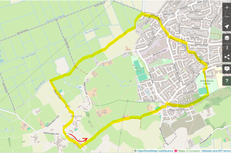
- With your back to the Blue Flame, turn left through the small hamlet of West End. You're looking for a narrow footpath on the left by a telegraph pole, approx 200 metres from the pub, that runs between a fence and a wall. It looked like the nettles were looking forward to a bumper summer.
- This route is part of The Nailsea Round and we'll follow it for much of the way. It's well signposted. Enter the field over a stile, and follow the left hand hedge boundary to the far end hedge. A now defunct bridge in the corner should be ignored. Instead, follow the hedge round to the right and you'll find a gate and footbridge into the next field.
- Follow the field uphill, one of the only slopes on this walk. There's an ancient stone stile over a wall ahead of you. There are likely to be cows in this field, or the next few fields. They showed no interest when I passed.
- Continue straight ahead through the next field, past barns on your left. You'll see the signposted path that takes you onto a farm track. Follow this, straight ahead initially, then arcing a little to the right to a gate, leaving the farmland.
- The new housing development of Nailsea is ahead of you, just beyond some stables. Bear left at the road. The housing development is on the other side. Cross to that side of the road and continue left. There's a track running to the right just beyond the housing development.
- This is a wooded track that separates some of the older housing of Nailsea from the new development. Follow this until there are no houses on either side, the path opens out and a high green sports fence appears on the left. Continue until a path head left towards the sports fields of Grove Sports Centre. Follow this past the football pitch on your left, towards the clubhouse, and cricket pitches either side.
- Exit the Sports Club onto the road, with The Ring O'Bells in front of you. Cross here, towards Holy Trinity Church.
- Follow Church Lane to the left in front of the church, continuing as it winds around, eventually past the Church Hall, then narrowing down a lane showing a 'no through road' sign. Some of the cottages here are 18th century.
- As Church Lane meets the main road - Queens Road - turn left. Stick to the pavement, continuing over Hannah More Road (past the Coop on your left). Cross straight over at the next junction, and continue onto Hanham Way, with Bakers the Butchers on your left.
- At the end of the housing development, cross a brick bridge and take the left hand footpath that follows the stream (rhyne). Please Keep To The Footpath in capitals is a sign on the gate, amongst many others.
- The path is clear from here. It follows the stream through a number of fields, again likely with cattle in some of them. Cross a farm track, continue into the next field. Eventually you'll pass through a gate across a short wooden beam bridge at a sluice gate.
- In the next field look for a concrete bridge over the stream on your left. There's a 3 bar wooden rail fence along side it, and a metal gate ahead of you onto a farm track.
- Take this track to start the return towards the pub. It passes some stables, and eventually meets the road - Nailsea Moor Lane. Continue straight ahead onto the lane, watching out for traffic coming from the right. At the next junction, turn right onto West End Lane and continue as the lane winds around past some lovely old cottages, eventually reaching the Blue Flame.
The best pub walks are meant to be shared.
If you’ve followed this route, found a better path, got lost, uncovered a standout pint somewhere else, or simply have a story to tell, I’d be delighted to hear from you.
This site is as much about shared discoveries as it is about the walks themselves.
Add comment
Comments