

The Pilchard Inn, Bigbury-on-Sea
Pub Walk From Bigbury-on-Sea to Ringmore & Aylmer Cove, returning via the South West Coast Path, 4 miles

Try this Pub & Walk
Burgh Island doesn't need me to sell it to you.
Between the Art Deco hotel, the sea tractor, Agatha Christie's ghost, and roughly a thousand identical travel features written about it, it's already one of the most recognisable single images the whole of South Devon has to offer — the kind of place people half-recognise from a magazine years before they ever set foot near it.
You don't need convincing that Burgh Island and The Pilchard Inn exists, or that it's worth seeing. But perhaps you need convincing to turn your back on it first....
That's the odd trick this walk plays. You leave your car above Bigbury beach, with the island and its 'exclusive aquatic theme park' laid out in front of you, tide tables and sea tractors and all — and then you walk the other way. Uphill, through the village of Bigbury-on-Sea, out through the fields, towards what was likely the largest village around here, Ringmore. It's an ancient place with no lord, no manor house, and by most accounts no real recorded history at all, because it seems nobody was ever watching closely enough in this neck of the woods to write anything down.
It's the quietest possible contrast to where you've just started from. And that's rather the point. This walk doesn't ask you to choose between the art deco tidal spectacle and the thatched village solitude. It gives you both, in one afternoon, in the right order — so that when you finally do walk back across the sand to the Pilchard, tide permitting, you've earned it properly, on foot, rather than simply parked up and photographed it.
Because you absolutely should go.
Burgh Island and The Pilchard Inn deserves its Devon fame the way St Michael's Mount does for Cornwall — genuinely, not just as an Instagram backdrop. The only thing worth adjusting is your attitude on arrival.
About The Pilchard Inn, Bigbury-on-Sea


Last visit: June 2026
The first time I stood on this beach, decades ago now, I didn't know what a sea tractor was. I remember the particular, almost childlike astonishment of realising that the pub I was about to walk into would, in a few hours, be completely cut off from the mainland — that I could be genuinely holed up on an island, in a proper pub, waiting for the sea to let me leave. When "awesome" still meant awesome, that was about as awesome as Devon got.
The pub name, at least, is refreshingly simple. Not a person, not a ship, not a smuggler — just the pilchard itself, the shoals of sardine that this whole coast once fished, cured and lived off, spotted from a lookout hut at the top of the island and signalled to the boats below by a cry, a "hue," that gave the hut its name too. The pub has carried that plain, working name since 1336.
You already know the rest, because everyone does: a possible monastery guesthouse, fishermen turned smugglers, Agatha Christie, the tractor. It's on every postcard rack in the county, and I'm not going to pretend I can tell it better than the fifty websites that already tell it identically. What I can tell you is what forty years of coming back has actually shown me, which is a quieter story than the one on the postcards.
The wonder and excitement is still there. It's just a little harder to find than it used to be.
In the years since Covid sent half the country looking for a foreign holiday at home instead, Burgh Island has picked up a certain kind of visitor who seems to expect the same standard of service they'd get on Marylebone High Street, delivered at the same brisk metropolitan pace — which is a genuinely strange thing to demand of a pub that gets cut off by the sea. The odd thing is, it's the staff who've become more travelled and more polished over that time, while it's the customers who've somehow got less patient. That's backwards from how it's supposed to work, and it's cost the place a little of the local innocence I remember — local service, delivered at local speed, by people who weren't in a hurry because the tide wasn't either.
But here's what I've learned, and it's the real reason to make this walk: come when the tide is against you, not with you. Come in autumn or winter, when the crowds thin and the Pilchard becomes something closer to what it must have felt like a century ago — a small stone room holding out against actual weather, while everyone who wanted underfloor heating and a hot tub is tucked up in a holiday let somewhere, entirely missing the point.
Or, failing that, just wait. Watch the tide come in on a summer afternoon and you'll see the same thing happen every single day: the crowd checks its watch, remembers the causeway won't wait for anyone, and scuttles back across the sand toward the car park. You can almost feel The Pilchard exhale. What's left behind is a comfortably marooned community, something much closer to the pub I remembered all those years ago.
Whatever the crowd, whatever the season, I'll say this: the two young staff working the bar this week, Millie and Joe, handled a long queue of thoroughly impatient people with a calm I found genuinely impressive to watch. If the old innocence has gone from the visitors, it clearly hasn't gone from the people serving them — and they deserve to be named, in print, rather than folded anonymously into "the friendly staff" the way every other write-up does it.
Pub Key Information
| WEBSITE | https://www.burghisland.com/dine-with-us/the-pilchard-inn/ |
| ADDRESS | Burgh Island, Bigbury-on-Sea, Kingsbridge TQ7 4BG |
| PHONE | 01548 810 514 (Burgh Island Hotel reception) |
| WHAT3WORDS | ///paving.marmalade.pleaser |
| PARKING | Pay and Display at Bigbury-on-Sea car park. You can pay via an App, and you can get temporary WiFi access to download the App if you don't have it! |
| LOCATION | Bigbury and Bigbury-on-Sea is on the South Devon coast. Access is off the A379 between Kingsbridge and Plymouth on the B3392. |
| HANDY FOR | South West Coast Path, and the Avon Valley Estuary Walk. A passenger ferry serves Bantham on the other side of the Avon Estuary - it's seasonal, so check running times. |
Walk Overview
Leave the car above Bigbury beach with your back to the island — you'll see plenty more of it later — and climb through the village into open fields, heading for the village of Ringmore.
Ringmore is the older, quieter half of this pairing, and arguably the more historically important — a proper farming village long before anyone built a hotel on a tidal island nearby. All Hallows Church, dating from around 1240, holds a rare medieval wall painting and a stained-glass war memorial window called one of the most moving in the country — worth ten minutes, whatever your faith. The Journey's End, the village pub, deserves its own visit another day; if it's shut, as it may be on a Monday, don't read anything into it.
From Ringmore, a gentle National Trust gravel track drops you down to Ayrmer Cove — an accessible way to reach the coast and sea. Pick up the South West Coast Path here and turn east: fine views back to Bolt Tail near Hope Cove, and, ahead, your first proper look at Bigbury beach, Burgh Island and The Pilchard together on a clear day. The path runs on above Challaborough before dropping to the beach and back to Bigbury.
Check the tide before you rely on walking to the island; if it's in, the sea tractor does the job just as well, and with rather more entertainment value. Either way, you'll arrive at The Pilchard the way this walk intends: on foot, sandy, and glad of the pint waiting for you.


Walk Key Information
| START/FINISH | Public Car Park. Marine Drive, Bigbury-on-Sea, Devon TQ7 4AS. The payment machines are card or contactless only. |
| PARKING | As above. Ample parking spaces available. |
| GRID REFERENCE | SX 651 443 |
| WHAT3WORDS | ///gymnasium.flux.admires |
| DISTANCE/TIME | 4 miles / 6.5 km; approx 2 hours |
| ASCENT | 995 feet / 310 metres |
| PATHS/TERRAIN | Tarmac paths and lanes, fields, gravel tracks, coastal footpaths. |
| DIFFICULTY | Moderate. This is an undulating and rewarding route that squeezes nearly 1000 feet of elevation into 4 enjoyable miles. |
| PUBLIC TRANSPORT | Limited options. There isn't a service from Kingsbridge to Bigbury-on-Sea, but there is a multi-step route from Plymouth. |
| TOILETS | At the car park in Bigbury-on-Sea, and at The Pilchard, which is open every day. The Journey's End in Ringmore is currently closed on Monday and Tuesdays. |
| OTHER PUBS TO VISIT | The Journey's End in Ringmore is recommended. In Kingston, Punch Taverns' The Dolphin is stumbling a little and would welcome support. Away from the beach in Bigbury, try The Pickwick Inn. Across the River Avon in Bantham is The Sloop, a cracking pub. |
Walk Instructions: Choose what works for you
There are multiple ways to consume the route described below.
- Either follow the online Walk Directions below, or download and print a copy of the route.
- If you have the OS Maps App, you can follow a saved route directly in the OS App.
- Or download the GPX file for use with your chosen GPS-based tracker App, like Strava. Upload the file when you Create a New Route in the App.

Walk Directions
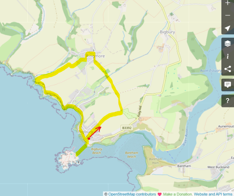
- From the upper section of the public car park at Bigbury-on-Sea, look for the footpath finger marker post named ‘Bigbury on Sea’ at the opposite side of the to the beach. With your back to the beach, set off in the direction of Challaborough, up a sloped concrete path to your left.
- After c.100m, reach the road and cross carefully to pass the bus shelter-turned defibrillator location on your left, heading uphill on Parker Road.
- The road leads uphill through the houses of Bigbury-on-Sea, and eventually passes into fields over a stile as you make your way to Ringmore.
- This is an undulating route and this first uphill section takes you to the brow of the first climb on ‘Mount Folly’. Beyond the houses, follow the way marker into the first of three fields, following the right-hand field boundary. Continue ahead.
- At the end of the 3rd field, turn left in the direction of Ringmore. Then through a gate into the next field and continue steeply downhill following the clear route now with the field boundary on your left. It drops down steeply.
- At a track at the bottom, look for a waymark direction post to the left, to climb up the next field. Follow the marked path that crosses this field towards a telegraph pole as your guide, just before a hedge. A metal gate takes you to steps down to a lane – it’s one of the two routes in and out of Challaborough so take care as you step onto the lane.
- The footpath continues on the other side of the lane, with a waymarked Public Footpath sign pointing into a field through a gate. Take this field path downhill with the hedge on your right.
- Cross a brook at the bottom to start the climb into Ringmore. The route is clear as you ascend vi kissing gates and field edges. A track along a hedge takes you onto a lane.
- Continue to a junction in the village, with Cross Manor in front of you. Bear right, past thatched cottages and the WI Hall, then turning left in front of All Hallows Church. It’s worth a look inside – there’s a superb commemorative stained-glass window to recognise those lost from the village in the two great wars.
- Again, take care here. It’s another of the routes into Challaborough and there’s a blind bend in front of the church entrance.
- Continue downhill, bearing left to pass The Journey’s End. Like all pubs in this area, it’s operating reduced hours, closed Monday and Tuesday when I visit.
- Almost opposite the front door, bear left uphill, and head uphill to a junction, with an obscured sign for Ayrmer Cove pointing left, past Smugglers Cottage, a wonderfully thatched building on the corner.
- As this lane ends, you’ll see the route to Ayrmer Cove starts on a gravelled path to the left. It runs from here down to the beach, level at first before a gentle descent, the easiest section of this walk.
- The ups and downs haven’t ended yet, however! At the beach, join the South West Coast Path to the left for the return to Bigbury, via Challaborough. The steep path up to Toby’s Point from Ayrmer Cove is the hardest uphill, but the views across to Burgh Island at the top make up for it.
Other Pubs to try in Devon

Slapton Ley Nature Reserve & the Slapton Sands D-Day Memorial
3 miles

Salcombe to East Portlemouth Circular, via Ferry & the South West Coast Path
3.8 miles

Fabulous Coast Path walk around Prawle Point, Devon's most southerly tip
5.8 miles