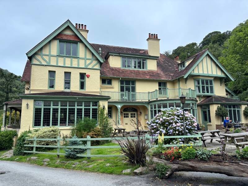
The Thatch, Croyde
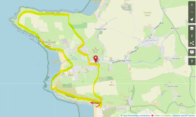
Walk from Saunton Sands to Baggy Point & back via The Thatch and Saunton Down, 7.9 miles.

There are routes in North Devon that feel like they were designed by someone who wanted to give you everything at once — beach, dune, headland, coast path, open down — and this is one of them!
Eight miles from Saunton Sands, around Baggy Point near Croyde, and back over the top of Saunton Down, with 1,200 feet of climbing and views that earn every one of them.
The Thatch, a sixteenth-century thatched pub in Croyde, hasn't changed in my living memory — lamp-lit, low-beamed, log fires, surf report chalked up in the bar.
The Thatch is as much a part of this landscape as the headland you've just walked around. It doesn't try to be anything other than what it is, and what it is has been drawing people, like me, back for decades.
About The Thatch, Croyde
Last visit: June 2026
The Thatch has been here, in one form or another, since the sixteenth century — low-beamed, lamp-lit, with fires burning and a long bar doing steady, uncomplicated work. It was known for years as the Thatched Barn Inn. The name has changed; nothing else has.
The staff look like they've either just come from the beach or are heading there the moment their shift ends. Outside, sun-trap terraces catch whatever the Atlantic weather is prepared to offer. Inside, it's dark and warm and unhurried. It almost certainly pours St Austell ales — Tribute is the one to go for — alongside the usual lagers and ciders that a crowd this close to a campsite and a surf break will always require.
The crowd skews young, and rightly so. Croyde has been drawing that particular tribe — boards, vans, rash vests & wet hair — for as long as anyone can remember, and The Thatch is where they end up. But look around and you'll also find foreign visitors who've made this something of a pilgrimage, and older regulars who've perhaps been coming since before the current generation was born. The pub holds all of them without effort.
A Personal Note
Forty years ago, a group of old Cardigan school friends descended on Croyde for a surf weekend — one of those summers when we were about to scatter in our different directions, and you didn't quite know it was the last time you'd all be in the same place at the same time. We camped. We surfed, badly. We spent our evenings at the Thatched Barn Inn (of course, you can't put a group of Welsh rugby fans together without expecting close harmony singing).
Standing in The Thatch now, watching a group of young people at the bar doing exactly the same thing — the same noise, the same energy, the same complete lack of awareness that this moment will matter to them in forty years — it is impossible not to feel the continuity of the place.
Some pubs host memories. The Thatch seems to generate them, reliably, for generation after generation, without changing a thing.
That is not a small achievement. That is the whole point.


Pub Key Information
| WEBSITE | https://www.thethatchcroyde.co.uk/ |
| ADDRESS | The Thatched Barn Inn, Croyde, Devon, EX33 1LZ |
| PHONE | 01271 890 349 |
| WHAT3WORDS | ///opened.noble.shunts |
| PARKING | The Thatch has a small car park across the road. Parking for this walk is detailed in the walk description. |
| LOCATION | Saunton and Croyde are located on North Devon's Atlantic Coast, to the north of Barnstaple, on the way to Woolacombe and Ilfracombe. |
| HANDY FOR | Any of the other surfing hot spots on this stretch of coast, such as Woolacombe and Putsborough. The Tarka Trail follows a disused railway line from Barnstaple, the main town serving this part of the county. |
Walk Overview
There are circuits in North Devon that feel like they were designed by someone who wanted to give you everything at once — beach, dune, headland, coast path, open down — and this is one of them.
Eight miles from Saunton Sands, around Baggy Point and back over the top of Saunton Down, with 1,200 feet of climbing and views that earn every one of them.
The Thatch allows you to gather your strength before that final ascent of Saunton Down.
This provides one of the best views of the entire walk: Saunton Sands stretching south, Braunton Burrows beyond, and the whole arc of the bay laid out behind you. It's the kind of view that makes you forgive the gradient entirely.


Walk Instructions: Choose what works for you
There are multiple ways to consume the route described below.
- Either follow the online instructions, or download and print a copy of the route.
- If you have the OS Maps app, you can follow a saved route directly in the App.
- Or download the GPX file for use on your chosen GPS-based navigation application.

Walk Key Information
| START/FINISH | Saunton Sands Beach Car Park, off the Braunton to Croyde Road. |
| PARKING | Plenty of parking at the Saunton Sands Beach Car Park. Number plate recognition on entry, pay on exit. |
| GRID REFERENCE | SS 447 378 |
| WHAT3WORDS | ///rooting.conforms.driver |
| DISTANCE/TIME | 7.9 miles / 12.6 km; approx 3.5 hours |
| ASCENT | 1193 feet / 370 metres |
| PATHS/TERRAIN | A real mixture! Some sandy sections, wooden walkways, lanes, pavements, grassy cliff top tracks, narrow stony paths, farm tracks. Steep, steady climb out of Croyde up to Saunton Down to end. |
| DIFFICULTY | Moderate |
| PUBLIC TRANSPORT | Buses run between Braunton and Croyde, passing the Saunton Sands Beach entrance. |
| TOILETS | At the beach car park, and numerous options in Croyde. |
| OTHER PUBS TO VISIT | Many pubs between Braunton and Woolacombe cater for holidaying families and the surfing crowd. The Manor House Inn is a family friendly pub in Croyde. The Rock Inn & The Kings Arms at Georgeham are good. |
Directions
- From the car park, look for the toilets below the Grill. The coast path runs uphill to the left of the toiles, uphill towards the Saunton Sands Hotel. In front of the hotel, follow the path around the children’s play area and tennis court, up to the main road. It’s busy, so take care as you cross.
- Through the gate on the opposite side, go immediately left. (We’ll be coming down the hill in straight ahead on the return journey). The path here felt like it might become overgrown, but this is a busy South West Coast Path route so should be maintained.
- The path here starts uphill, but soon levels off and widens, running parallel and above the main coast road. Eventually a footpath marker points uphill to Croyde. It looks like a new section designed to avoid a short, tricky SWCP route along the main road. We’re taking the original Coast Path route.
- At the marker, continue straight ahead instead. You’ll see that the road below curves to the right around a bend, with an interesting circular house built looking out to sea. Make note of this – the path we’ll be aiming for when we join the main road runs to the coast to the right-hand side of that house.
- The path also curves around to the right, and then drops towards the road. TAKE CARE. You need to cross over and make your way BACK UP HILL towards the bend, 50m ahead. The footpath runs to the right-hand side of the circular house in front of you.
- The path off the main road runs down steps to the coast path to make its way to Croyde. The signposts point towards Baggy Point, the headline you see across the other side of Croyde Beach.
- The path soon drops down towards the beach. If the tide is out, follow the Coast Path route across to the other side of the beach, leaving past the café & toilets. However, if the tide is in, or coming in, the alternative route is signposted into the dunes within 50m of joining the beach from the cliff.
- The path up the dunes from the beach is hard work! But levels off for easier walking soon. Continue on a sandy track, then passing an entrance into a holiday park on the right. Keep straight ahead. As the path emerges onto a lane, head towards a wooden gate to the left into a field.
- Follow the path diagonally across the field (perhaps this is a car park in high season times). As you leave the field, turn right over a footbridge towards a playing field on a gravel path. It runs into a holiday park. Continue through the park, a meandering drive that leads to the entrance/exit onto the main road.
- Turn left to pass the access to the beach (toilets are 25m towards the beach). Continue straight ahead, signposted Baggy Point.
- This is a popular walking route for visitors to Croyde. The level path, initially along a lane with a few refreshment break options, is busy. The main aim from here is the summit above Baggy Point. Continue along the lane until you pass the last of the sea-facing houses, then soon after proceed through a wooden gate. Many people will continue along the level path but take the route uphill.
- Continue to follow the path uphill around the headland, eventually passing the Baggy Point Coastguard Pole. The path begins to level out soon afterwards, and continues now with superb views of Putsborough Sands and Woolacombe.
- Continue through a number of wooden gates, and 1 mile from Baggy Point you’ll see the first footpath junction sign on this generally level route. The signpost is named ‘Baggy’ and indicates Croyde 1 mile. Take this grassy track up the slope, following ahead with the hedge on your right.
- Proceed through a kissing gate into the next field, and straight ahead to a gate onto a farm track. Turn left on the track, which soon bends to the right as it continues downhill.
- Eventually passing Cherry Tree Farm, look for a footpath sign to the right down a narrow path. It emerges into a residential area, past the ‘Old Coastguards’ house. At the main road, turn left, then right at the junction to drop down into the heart of the village. Continue past the car garage & village Hall, and turn right to head up towards The Thatch.
- To begin the return to Saunton, take Cloutman’s Lane across the road from The Thatch. Continue past Rowan Cottage, up the lane marked by a No Through Road sign. The concrete drive heads uphill. Follow the drive on a bend round to the right, then within 20m continue straight ahead to a gate to the right onto a wooded path. This is called Down Lane.
- This path can be steep, and a little unrelenting, but worth it! Down Lane continues up to the Saunton Down, initially leaving the wooded section and opens out into a gorse & fern area with views down over Croyde, and then through a pair of kiss gates into sheep fields.
- Follow markers to cross fields with superb views of Saunton Sands and Braunton Burrows as you crest Saunton Down. The grassy path starts diagonally downhill, and eventually enter woodland, down steep steps.
- This path takes you back to the point where you crossed the road near to the Saunton Sands hotel. It’s a narrow path, already starting to become overgrown in mid-June.
The best pub walks are meant to be shared.
If you’ve followed this route, found a better path, got lost, uncovered a standout pint somewhere else, or simply have a story to tell, I’d be delighted to hear from you.
This site is as much about shared discoveries as it is about the walks themselves.
Add comment
Comments