

The New Inn, Blagdon
A circular walk of Blagdon Lake, along paths, lanes and fields, 6 miles

Try this Pub & Walk
What a start to this walk! You get the whole walk laid out in front of you before you've taken a single step, from the New Inn beer garden, surely one of the best views in North Somerset.
Blagdon Lake fills the valley below — 440 acres of it, a Site of Special Scientific Interest sitting inside the Mendip Hills AONB, all of it created just over a century ago by damming the River Yeo. That's the wow factor, and it's free the moment you arrive.
The other reason to tackle this walk is the pub itself, of course, and the timing. Both of Blagdon's pubs have looked shaky in recent years — the Seymour Arms in and out of new hands since 2023, and the New Inn drifting through a run of tenants after its long-serving landlord retired. Now the New Inn is in the hands of Yeo Valley Organic, the family firm from up the same Yeo valley, already well known, trusted and an established hospitality success story locally at their HQ Canteen.
They've got a view that was always going to sell itself; what they're adding is the reason to stay for a second pint. Go now, while it's still becoming what it's about to be.
About The New Inn, Blagdon


Last visit: July 2026
The New Inn is Grade II listed, genuinely 18th Century in its bones. I checked Historic England's listing which describes a long range under a double Roman tile roof, colour-washed render with stone copings, small-paned cottage casement windows at one end, handsome Victorian sash windows with marginal glazing in the centre, something later at the other. So I guess this was three cottages knocked into one long pub over two and a half centuries, not built as one, and you can get a feel for that on a quick tour.
Inside: old beams, horse brasses, giant stoves for winter. Outside: that view, and a front garden and hanging baskets that make the first impression before you've even reached the door. Wadworth's 6X is the regular on the bar, with a rotating guest ale alongside it, Butcombe today, which didn't have to travel far.
The ownership story matters here more than in most entries.
The New Inn drifted through a difficult run of tenancies after its long-standing landlord retired, and — a few hundred yards up the same road — the Seymour Arms was going through its own version of the same trouble. Two pubs, one small village, both looking fragile at the same time — not a coincidence so much as what happens to rural pubs generally when trade is light.
What makes Yeo Valley's takeover of the New Inn different from an ordinary change of hands is that this is a business with a genuine stake in the village's sense of itself, not an outside operator looking for a site, or a tied house charging punitive rents.
Their HQ Staff Canteen up the hill has built a loyal following on unpretentious, organic, locally-sourced food served without ceremony, and the same family already runs the farm, the organic garden, and much of Blagdon's working life. Slotting a proper community pub into that picture isn't a stretch for them — it's an extension of what they already do well, just with a fireplace and a pint attached. On the Tuesday lunchtime I visited, that was already visible: Yeo Valley staff popping down from the office alongside locals and passing visitors, in a pub that felt like it was being quietly, deliberately brought back to life rather than merely kept open.
Pub Key Information
| WEBSITE | https://new-inn-blagdon.co.uk/ |
| ADDRESS | Park Lane, Blagdon, BS40 7SB |
| PHONE | 01761 258157 |
| WHAT3WORDS | ///boxing.character.decide |
| PARKING | Plenty of parking at The New Inn, some on street parking on Park Lane too. |
| LOCATION | Blagdon is a village in North Somerset. It is located in the Mendip Hills, a recognised Area of Outstanding Natural Beauty. The village is about 12 miles (19 km) east of Weston-super-Mare and 12 miles (19 km) south west of Bristol, on the A368 road to Bath. |
| HANDY FOR | The Limestone Link Path, which connects The Mendips with the Cotswolds. |
Walk Overview
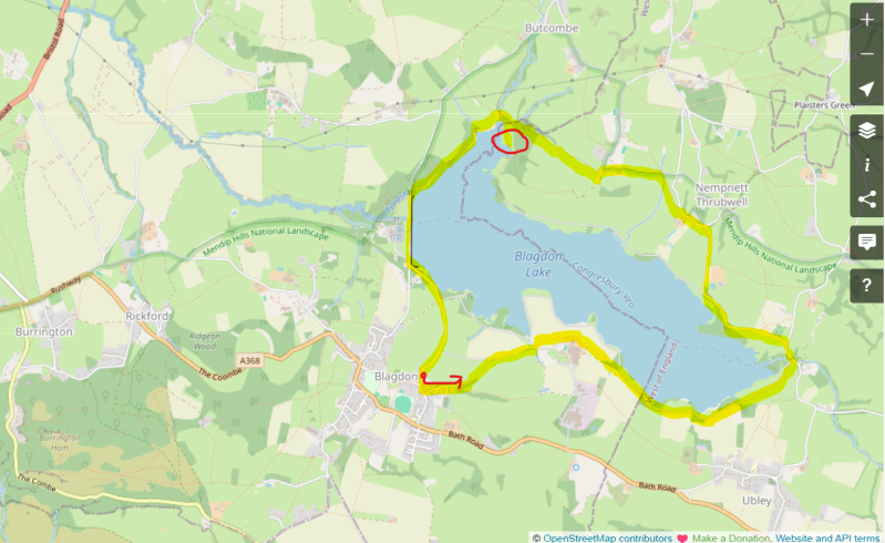
This is one of those walks where you can see the entirety of it laid out in front of you from the start. It’s a circuit of Blagdon Lake, using a combination of Public Footpaths, farm tracks, fields and very quiet lanes to navigate the 6 mile loop that is visible almost entirely from the lovely garden of the New Inn at Blagdon.
On the Southern side of the lake, the walk is near to the lake rather than along it. Direct access is limited by Bristol Water to those with a license to fish for trout. The route follows extremely quiet lanes on the northern shore with lake views.
Finally, there’s safe public access to the shoreline at ‘Butcombe Bay’ in the North West corner of the Lake, then a shoreline path to the dam at the West end of the lake.
There’s been acclaimed trout fishing here since the Lake opened, damning the River Yeo, in the early 1900’s. Occasionally, the Victorian Pumping Station behind the dam is open to visitors, a Grade II listed building.
Numerous online routes for this walk are brief, or mix up left and right! This is the definitive walk description as of July 2026.


Walk Key Information
| START/FINISH | The New Inn, Park Lane, Blagdon, BS40 7SB |
| PARKING | Plenty of parking at The New Inn, some on street parking on Park Lane too. |
| GRID REFERENCE | ST 505 589 |
| WHAT3WORDS | ///boxing.character.decide |
| DISTANCE/TIME | 6 miles / 10.8 km; approx 3 hours |
| ASCENT | 360 feet / 111 metres |
| PATHS/TERRAIN | Quiet lanes, grassy paths, gravel footpaths. At the start of the walk, below the New Inn, some livestock fields towards and around Halt Farm on the Southern side of the lake. From east end of Lake around lanes to West Town, routes are easy. |
| DIFFICULTY | Moderate. The final return to the village is the only strenuous hill, but I marked this as moderate since the fields covered in the first section are uneven (‘ankle breakers’ I call them – where ground from many sunken hooves has hardened in the sun), paths unclear through the fields on the southern part of the lake – a strimmer team would be useful in parts. And if it’s wet, trousers and boots would be soaked in long grass if the cattle haven’t yet had their way. Some path diversions from OS route to navigate too. |
| PUBLIC TRANSPORT | Buses from Bristol and Weston-Super-Mare pass through Blagdon. |
| TOILETS | At the New Inn |
| OTHER PUBS TO VISIT | Plume of Feathers at Rickford is excellent. Further afield The Crown at Churchill is superb. You might also consider something different: Hedgers Cider at Redhill, or Barley Wood Orchard near Wrington. |
Walk Instructions: Choose what works for you
There are multiple ways to consume the route described below.
- Either follow the online Walk Directions below, or download and print a copy of the route.
- If you have the OS Maps App, you can follow a saved route directly in the OS App.
- Or download the GPX file for use with your chosen GPS-based tracker App, like Strava. Upload the file when you Create a New Route in the App.

Walk Directions
Blagdon Lake is a long, elegant ribbon of water tucked beneath the northern escarpment of the Mendip Hills, created in the early 1900s to supply drinking water for the good people of Bristol and still managed today by Bristol Water as part of the city’s reservoir network. Though technically a working lake, it feels anything but industrial: wooded shores, quiet inlets, reedbeds alive with birds, and a necklace of farms and hamlets—West Town, Holt Farm, Butcombe—give it the character of a rural valley rather than a utility.
From the car park of the New Inn, take a moment to admire the view from the pub garden, and to get a feel for where you’re heading. To the right-hand side on this side of the lake initially, then looping around at its eastern end, before returning on the other side and then over the dam before climbing back up to where you are.
- Leave the New Inn and visit St Andrew’s
Turn left out of the New Inn car park and walk up Park Lane towards Church Street. Almost immediately you see St Andrew’s Parish Church to your right — well worth a brief detour (see Notes below).
- Turn onto Grib Lane
Continue on Park Lane for 50 metres, then turn left onto Grib Lane, signed as a No Through Road. After 100 metres, a footpath sign directs you left onto a grassy track in front of houses with fine views over the lake.
- Drop down into the first field
Continue for 50 metres and take the next footpath left, down concrete steps. The path meets a gate into a field — cattle were present when I visited — and you follow the right‑hand boundary downhill. Underfoot it’s tough going: sun‑baked hoof prints make the descent uneven.
- Navigate Holt Farm’s diverted path
Exit the field through a gate and walk towards the farm track ahead. A footpath marker sends you right, then almost immediately left into another field. Although the OS map suggests the path goes through Holt Farm’s farmyard, the waymarks divert walkers around a small wooded bank up ahead instead. The diagonal route now across rough, uncut grass is unestablished and would be soaked in wet weather. A series of footpath gates leads you through several cattle fields beyond.
- Follow the hedge to the footbridge
Once beyond the bank, eventually the route aligns with a hedge on your right. Look for a footpath marker showing the exit near the end of the field: cross a short footbridge, then turn left onto the farm track.
- More rough fields
Enter the next field and keep left. Again, the grass is long and the path indistinct — gaiters or waterproof trousers would be welcome on a wet day. Some sections clearly need strimming; I’ll be contacting the council.
- Walk beside Bristol Water’s private lakeside drive
The route continues through a succession of fields and short wooded sections, always with a hedge or fence on your left. Beyond that hedge lies a wonderful gravel track — Bristol Water’s private lakeside drive. It would make a superb walking route if access were permitted, but the company cites algae and water‑quality concerns to justify restrictions.
- Reach the lane
A wooden kissing gate brings you out onto a quiet lane. Turn left. The road isn’t busy, but take care. Keep left at the first junction, and again at the next — gratefully ignoring Awkward Hill rising steeply on your right.
- Start up Chapel Hill
Pass Grove Farm on your left and begin the ascent of Chapel Hill. Look for a footpath sign directing you left up the bank. In the field, head diagonally uphill to rejoin the lane, cutting off the corner of Chapel Hill and enjoying softer ground.
- Enter West Town
Bear left on the lane and soon reach the hamlet of West Town. Walk past the multi-storey Bellevue House, turn left at the junction, then after 25 metres take the public footpath to the right, over a stone slab stile.
- Cross the fields towards the woods
Follow the hedge immediately on your right and head straight across the field to a footpath gate. This leads into rough grassland and then shady woodland. Continue straight ahead.
- Optional shoreline spur to Butcombe Bay
As you approach the first footbridge, take a moment to break left out of the woods to follow a grassy path through a field towards the lake shore. This is the north‑west corner of Blagdon Lake — Butcombe Bay, the only true public access to the water. The views are excellent: the dam ahead, and on the hillside beyond, the striking Combe Lodge, designed by the same architect as Bristol University’s Wills Building and once home to the Wills family.
Return to the footbridge to continue the circuit.
- Cross the three footbridges
Cross the first footbridge, then two more in quick succession. The path becomes more established then, with gravel underfoot as you leave the wooded path and start to get closer to the dam. The lake is below you on the left all the way.
- Reach the dam
The path meets the road at the dam. Turn left. The Victorian pumping station stands opposite — closed for repairs when I visited. Cross the dam to the far side.
- Climb back to the New Inn
Once across, take the left‑hand turn onto Park Lane. After a level start, the lane climbs steadily back to the New Inn. You’ve earned your drink.
Additional Notes
The Church of St Andrew and the Tale of Sir Lancelot.
St Andrew’s Parish Church sits close to the New Inn, itself a “new church” in its current form. Inside is a striking stained‑glass memorial to the men of Blagdon lost in the First World War:
“Greater love hath no man than this, that a man lay down his life for his friends.”
Augustus Toplady served as vicar here from 1762 to 1764; he is best known for the hymn Rock of Ages, said to have been inspired during a storm in nearby Burrington Combe, down the road.
The site has hosted several churches: a Saxon or Norman original, a second consecrated in 1317, a third built in 1821, and the present church of 1908, funded by W. H. Wills — later Lord Winterstoke — of Combe Lodge.
So it could be that this is Church #4 or #5 on this site, showing the determination of the local community to Worship. It brings to mind Monty Python’s Holy Grail and the tale of Sir Lancelot’s father, who built castle after castle on a swamp until one finally stayed up.
NARRATOR: The Tale of Sir Lancelot.
FATHER: One day, lad, all this will be yours!
PRINCE HERBERT: What, the curtains?
FATHER: No. Not the curtains, lad. All that you can see, stretched out over the hills and valleys of this land! This'll be your kingdom, lad.
HERBERT: But Mother--
FATHER: Father, lad. Father.
HERBERT: B-- b-- but Father, I don't want any of that.
FATHER: Listen, lad. I built this kingdom up from nothing. When I started here, all there was was swamp. Other kings said I was daft to build a castle on a swamp, but I built it all the same, just to show 'em. It sank into the swamp. So, I built a second one. That sank into the swamp. So, I built a third one. That burned down, fell over, then sank into the swamp, but the fourth one... stayed up! And that's what you're gonna get, lad: the strongest castle in these islands.
Other Pubs to try in Somerset

West Mendips Circular Walk to Dolebury Warren and favourite 5* Churchill pub.
5 miles


Beacon Batch, Burrington Combe & Rickford – Layers of Mendip History
6.5 miles