The Rattlebone Inn, Sherston Pub Walk
Circular Wiltshire walk from Sherston to Easton Grey on the fringe of the Cotswolds, 6.3 miles

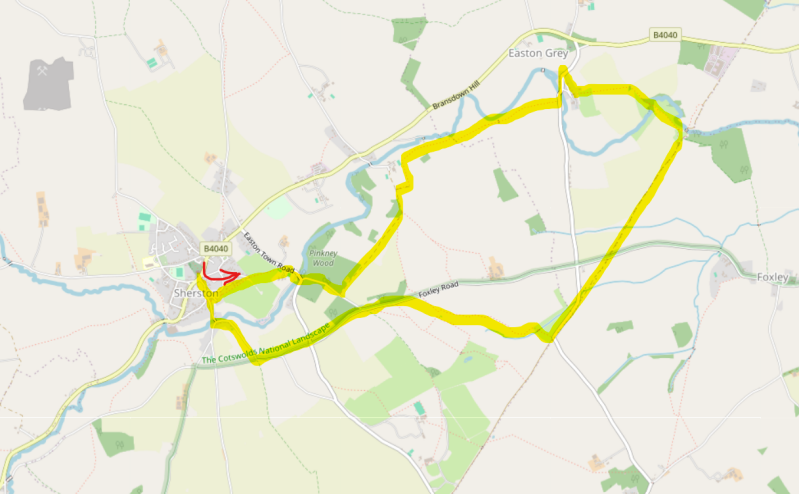
This circular route begins at The Rattlebone Inn at Sherston — already one of the most attractive villages in the southern Cotswolds — before drifting out into deeply rural countryside towards the improbably picturesque village of Easton Grey.
Sections of the walk follow the Palladian Way, a long-distance route linking landscapes and settlements associated with England’s architectural and estate-building heritage. And thank goodness Historic England helps protect these places for generations to come.
The route also intersects with the ancient Fosse Way, a reminder that these landscapes have been shaping movement and settlement for nearly two thousand years.
Easton Grey itself carries intriguing historical associations, including connections to former Prime Ministers H. H. Asquith and Arthur Balfour, adding another layer of political and social history to an already rich landscape.
The walk concludes at The Rattlebone Inn — all low beams, old stone, restrained confidence and the quiet sense that nothing much needs explaining. Apart from the Battle of Sherston in 1016, of course.
About The Rattlebone Inn, Sherston.
Last visit: May 2026
The Rattlebone Inn sits at the heart of the pretty Wiltshire village of Sherston. It's all uneven stone floors, dark beams polished by centuries of elbows, and enough atmospheric corners to hide a minor royal, a sheep smuggler, or a tired walker escaping horizontal rain that can, apparently, soak you through to the underpants in this part of the world.
The name alone deserves admiration. “Rattlebone” sounds less like a pub and more like a character from a forgotten West Country folk tale. The inn takes its name from the legendary figure of John Rattlebone, said to have fought during the fierce Battle of Sherston in 1016, when the forces of Edmund Ironside clashed with the invading Danes under Cnut in and around the village streets.
According to local tradition, Rattlebone was a giant of a man — a blacksmith or warrior depending on which version you hear after the second pint — who fought with such ferocity that he became woven into Sherston folklore. One tale claims he wielded an enormous battle axe; another that he continued fighting despite terrible wounds.
As well as the pub sign, a wooden carving of John hangs by a seat at the bar. The barman enthusiastically told me that "my Dad says this is the spot where he bled out following the Battle of Sherston", though regulars may quietly note that he appears to have expired in several different parts of the pub over the centuries, depending on which wall the carving was hung on.
I love these old pubs. They adjust and lightly modernise over time, but not in that consultant from Shoreditch way. Chairs still creak. Fireplaces look as though they have witnessed agricultural disputes, clandestine romances, and several generations arguing about whether it might rain later. Dogs sprawl with the confidence of regulars.
And then there’s Sherston itself. The village looks like someone asked a film set designer to create “ideal rural England”. Limestone cottages line the broad high street, the clue that Sherston used to be a thriving market town. Cottage names call out the tradespeople of their day.
The pub excels at one of Britain’s great pleasures: the transition from damp outdoors to warm indoors. Few experiences rival peeling off a raincoat beside a pub fire while a pint appears in your hand as if summoned by instinctive national memory. You could lose an afternoon here, as Prince Harry likely did a few times while he was living at nearby Highgrove.
But what truly “sells” The Rattlebone is something harder to manufacture: atmosphere without pretension. It manages to feel welcoming without trying too hard — a vanishing skill. Walkers, cyclists, locals, muddy dogs, couples escaping cities, and curious travellers all seem to coexist naturally beneath its beams. You are not processed through the pub; you are absorbed into it for a while.
There are pubs you visit because reviews told you to. There are pubs you visit because they’re convenient. And then there are pubs like The Rattlebone Inn — pubs that remind you why Britain became a nation of pub obsessives in the first place.
I loved it.


Pub Key Information
| WEBSITE | https://www.therattlebone.co.uk/ |
| ADDRESS | Church Street, Sherston, near Malmesbury, Wiltshire, SN16 0LR |
| PHONE | 01666 840871 |
| WHAT3WORDS | ///cliff.imposes.laminate |
| PARKING | Parking on the main street of the village, or one of the side streets. |
| LOCATION | Sherston sits north of the M4 in Wilthsire, in a triangle formed by Malmesbury, Tetbury and Chipping Sodbury. |
| HANDY FOR | The Palladian Way; Macmillan Way; White Walls Way; Fosse Way and not too far from the Cotswolds Way. |
Walk Overview
This circular route begins in Sherston — already one of the most attractive villages in the southern Cotswolds — before drifting out into deeply rural countryside towards the improbably picturesque village of Easton Grey.
Sections of the walk follow the Palladian Way, a long-distance route linking landscapes and settlements associated with England’s architectural and estate-building heritage.
The route also intersects with the ancient Fosse Way, a reminder that these landscapes have been shaping movement and settlement for nearly two thousand years.
Easton Grey itself carries intriguing historical associations, including connections to former Prime Ministers H. H. Asquith and Arthur Balfour, adding another layer of political and social history to an already multi-faceted walk.
This is Walk 4 from Sherston Footpath Group's Walking Guide.


Walk Instructions: Choose what works for you
There are multiple ways to consume the route described below.
- Either follow the online instructions, or download and print a copy of the route.
- If you have the OS Maps app, you can follow a saved route directly in the App.
- Or download the GPX file for use on your chosen GPS-based navigation application.

Walk Key Information
| START/FINISH | The Rattlebone Inn, Church Street, Sherston, near Malmesbury, Wiltshire, SN16 0LR |
| PARKING | Parking on the main street of the village, or one of the side streets. |
| GRID REFERENCE | ST 854 860 |
| WHAT3WORDS | ///cliff.imposes.laminate |
| DISTANCE/TIME | 6.3 miles / 10 km; approx 3 hours |
| ASCENT | 390 feet / 120 metres |
| PATHS/TERRAIN | Quiet country lanes, paths across fields, stone tracks. Some stiles and gates. Fields shared with cattle in some places. Navigation easy. |
| DIFFICULTY | Easy |
| PUBLIC TRANSPORT | A few bus services call on Sherston, notably the 41 Malmesbury to Chipping Sodbury service. A service from Bristol also visits. Chipping Sodbury is served from Bristol. |
| TOILETS | At The Rattlebone |
| OTHER PUBS TO VISIT | The Vine Tree at Norton; The Old Royal Ship at Luckington; The Neeld Arms at Grittleton are all nearby. |
Directions
-
Go towards Malmesbury and turn right by the Rattlebone Inn into Noble Street, signposted for Acton Turville. The signpost sits on an area known as the Triangle, with an ancient Acer tree in the middle. This is known as the Jubilee Tree, as it was planted in 1897 to mark Queen Victoria’s Diamond Jubilee.
-
A short way down the hill look for a footpath sign to the left up the steps. Follow this straight ahead through the houses to a metal kissing gate and along a field edge with the back gardens of some lovely houses on your left.
-
Continue through the next kissing gate, veer diagonally right across the field, over a stile, then on the same line to another kissing gate in the field corner. There will likely be some horses in these fields.
-
Descend the steps to the road and head right, following the road with care downhill to Forlorn Bridge over the River Avon.
-
Make your way over Forlorn Bridge and immediately left up the hill. When the woodland on the left stops, turn left onto the signed track, going past Keeper’s Cottage. The area to your left is part of Pinkney Park estate land.
-
Continue on this track, passing through a large iron gate, which once retained Pinkney Park’s herd of deer, and follow the wall round to the left. Go through a metal field gate and immediately take the signed, diverted footpath on the right, which follows the field boundary.
-
Stay in the field and follow the path around the two field sides then across two adjacent stiles into a field on your right. The path sounds complex but it clearly signposted.
-
Continue with the hedge on your left across two more stiles. The path then veers right and through a gate before going diagonally across the field towards two large oak trees and a water trough. There were some curious cows in this field that kept well away.
-
Bear right following the tree line, cross two stiles (the first with a bridge) and continue alongside pheasant rearing pens then along the right-hand side of a post-and-rail fence.
-
Views of Easton Grey House and parkland lie to your left. A downward slope now takes you to a gate and out onto the road. Turn left over the bridge into the picturesque little village of Easton Grey. The bridge is probably 16th century while Grade II Listed Bridge House and collection of smaller buildings are 17th century , including the original laundry on the river which at one time serviced Easton Grey House, up the lane to the right next to Bridge House.
-
A short diversion left, up the hill for 500 yards, will bring you to the church, which is well worth a visit. We took this route, passing the old village Post Office on the right, then turned right behind it onto a level lane towards Easton Grey House. Then we picked up the route again, where the lane from Bridge House coming up from the bridge below.
-
In front of East Grey House turn left, following the footpath between buildings, across a rough car park and through a metal gate. Continue across the field to a stile and then through an arable field with fine, open views.
-
Go through a wide gap in the hedge at the end of that field and immediately turn right. Follow this rough path with the hedge on your right for 100 yards. Spy a gap in the hedge in the corner of the field and veer right down a steep path. At the bottom a bridge crosses the widened river with the ruins of Easton Grey Mill on the left.
-
Proceed straight ahead through a metal gate, then a kissing gate and on along the track, through another metal gate and finally cross a stile. This brings you back to the river beside the Fosse Way and is the site of a former Roman settlement. There were once important military and trading posts at this river crossing as it was approximately halfway between the cities of Aquae Sulis (Bath) and Corinium (Cirencester). There’s a pool and a large metal pipe crossing the river now.
-
Bear right up the hill along the Fosse Way, passing through a metal gate while being wary of possible off-road vehicles. After a ‘Roman road straight ahead’ 3/4 of a mile, go through another metal gate, cross a minor road and continue for 400 yards to join another road (muddy in wet weather). Continue ahead along this road until you rejoin the wide, stony track of the Fosse Way where the metalled road sweeps left.
-
As you join the Fosse Way track again, immediately turn right through the gate on a signed path, towards the left-hand corner of the field. Cross a stile and turn left alongside the hedge to the corner. Go over a stile, across a track and almost immediately go over a second stile.
-
Keep the hedge on your left for 700 yards until you reach the gate onto the road. Now turn left to follow the road for about ½ mile, taking the 3rd right hand turn off this lane onto Bustlers Hill. The lane proceeds downhill, then winds around towards a bridge, back in Sherston.
-
Head right over the bridge onto Tanners Hill, which rejoins the route from the start on Noble Street and returns to The Rattlebone.
Notes
Congratulations to Sherston Parish Council for curating and promoting a series of walks around the village. They're excellent. I selected this particular walk to take in Easton Grey, largely due to its links with Asquith and Balfour.
The path follows a route that I hadn't heard of previously, the Palladian Way, a route that started as an idea from a keen walker who took retirement and turned it into a determined hobby. More details on the Palladian Way available here.
Walking around Sherston, and considering the Palladian Way's celebration of architecture, highlighted the importance of our heritage. I didn't fully understand how the properties and vistas of this great country of ours are maintained. So I wrote a blog about it.
Other Pub Walks to try in Wiltshire
The Kennet & Avon Canal, from Bradford-on-Avon to Bath via The Hop Pole Inn.
11 miles