

The Sailors' Safety, Pwllgwaelod
Pembrokeshire Coast Path loop of Dinas Head, via Cwm-yr-Eglwys, 3.3 miles

Try this Pub & Walk
Places like this deserve to succeed.
I first knew the Sailors' Safety as the kind of pub you sought out when the weather was doing its worst. A low-slung Pembrokeshire building tucked behind Pwllgwaelod beach, it seemed made for dark winter evenings: the wind howling outside, the fire burning inside, and my imagination full of stories of those who sheltered here over the centuries.
Pwllgwaelod itself owes its existence to the sea. Before roads connected communities, this sheltered cove was a working landing place where small coastal trading vessels loaded and unloaded cargo, fishermen earned a living, and mariners sought refuge from Atlantic weather. A pub here was part of the landscape.
When the Sailors' Safety closed a few years ago, it felt as though a little of that landscape had disappeared. I was genuinely disappointed to find its doors shut.
Returning this year was therefore a real pleasure. The people behind Newport's Llys Meddyg have achieved something that many aspire to but few accomplish. They've respected everything that made the Sailors' Safety special while polishing it for a new generation.
The old bar remains full of nautical character. Outside, generous terraces, a beachside fire pit and thoughtful spaces encourage people to linger over lunch, dinner or a pint while looking across Fishguard Bay. The food has quickly earned an excellent reputation, and the atmosphere suggests this is no longer simply a pub to run for in rough weather, but a destination in its own right throughout the year.
The good news for walkers, serious and not, is that one of Pembrokeshire's finest short coastal circular walks begins and ends here. A gentle loop around magnificent Dinas Head takes in dramatic cliffs, wide sea views, the sheltered cove of Cwm-yr-Eglwys, one of the most rewarding sections of the Pembrokeshire Coast Path. It's the perfect companion to a pub that feels every bit as comfortable welcoming muddy boots as it does serving memorable meals.
About the Sailors' Safety, Pwllgwaelod


Last visit: July 2026
The team behind the rescue is Llys Meddyg, the well-regarded small hotel up the road in Newport — itself a homecoming story, built by a family who returned to their Welsh roots after years away to create something properly good. They've now brought the same instinct and confidence to bear on the Sailors' Safety, and the balancing act shows real judgement: a new dining room, all light and window and local art, sits alongside a bar that's barely changed at all — low ceilings, nooks and crannies, and the same accumulated nautical clutter that's always been there.
Outside, there's now generous, thoughtfully done seating and a fire pit right above the beach, fleece blankets provided for the evenings that need them. It was packed on my visit, and rightly so.
They describe themselves, on their own Facebook page, as simply "a little restaurant by the sea" — and the food, by every account I've read since sounds genuinely excellent, built around the same local seafood and foraged ingredients Llys Meddyg is known for.
As you might expect from a little restaurant by the sea, there's a real enhancement to the dining area, but it hasn't tipped the balance entirely towards restaurant over pub — there's still real room to simply drink, or to eat informally in the bar rather than book a table in the more formal dining room. It's what gives the place its all-round atmosphere: as much a proper pub as it is somewhere to eat well.
There's a real tension sitting underneath a project like this, worth naming plainly: the very things that make a pub like the Sailors' Safety worth finding — remote, unpolished, seemingly untouched by time — are also what leave it with no natural defence against financial challenges and closure. Yet keeping a place like this alive requires exactly the kind of investment and imagination that can risk sanding off the things people loved in the first place. On the evidence of my visit, Llys Meddyg have found the recipe. If they've bottled it, I'd genuinely like a case.
The building itself has stood for some five hundred years, though it closed for a period in the 90's. Its name has drifted back and forth too: originally the Sailors' Safety, referring to a light the pub itself once kept burning as a guide to ships offshore, it became the Old Sailors for a time before reverting to the original. I remember it as the Sailors' Safety from before I left the area in the '80s, and returning years later to find it going by the other name was one of those small, disorienting jolts that tells you how long you've actually been away.
It's kept genuinely good company across that long life, too.
Dylan Thomas is recorded as having made the trip specifically to eat here — not passing through on his way to somewhere else, but travelling the best part of fifty miles up the coast from his own home at Laugharne, deliberately, for this pub.
And the connection to this stretch of water runs deeper than one man's appetite: Lower Fishguard, the old harbour visible right across the bay from where you'd be sitting, stood in as Llareggub itself for the 1971 screen version of Under Milk Wood. Which makes Thomas, in his own way, an early example of exactly what the Sailors' Safety is becoming again now — a destination in its own right, worth the drive, rather than somewhere you happen to end up. People are once again travelling specifically for this pub. He just got there about seventy years early.
The one practical note worth passing on: this is a genuinely popular spot now, down a narrow lane with limited parking, so booking ahead — and arriving a little before your table time — will save you the disappointment of a wasted trip. It's the kind of problem a pub only has because it's doing something right.
Pub Key Information
| WEBSITE | https://www.facebook.com/profile.php?id=61564202271261 |
| ADDRESS | Pwllgwaelod Beach, Dinas Cross, near Newport, SA42 0SE |
| PHONE | 01348 811486 |
| WHAT3WORDS | ///sharpens.these.doghouse |
| PARKING | Public car park and toilets in front of the pub. The pub is popular, and car park spaces limited, especially during school holidays. Arrive early. |
| LOCATION | Pwllgwaelod sits at the end of a road off the A487 Fishguard to Newport road. You'll see the junction at Dinas Cross. |
| HANDY FOR | Newport and Fishguard. St David's and the Preseli Hills are easily within reach. |
Walk Overview
A proper Pembrokeshire Coast Path classic, and a rare thing on this coastline — a genuinely circular walk, roughly 3.3 miles, easy enough to suit most walkers while still delivering high cliffs, big views, and a real sense of headland drama.
From Pwllgwaelod the path climbs onto Dinas Head itself, the small peninsula that very nearly becomes an island, with the ground opening out into gorse and heather as height is gained. The trig point at the top, Pen-y-Fan, is the walk's high point in every sense — 142 metres up, with views stretching along the coast, inland to the Preseli Hills, and across to Fishguard Bay and Newport. From there the path drops back down towards Cwm-yr-Eglwys (meaning 'church'), one of the first beaches I ever knew as a child, and still about as good a spot for a young family as this coast has to offer, its ruined church standing quietly above the sand.
From the church, the walk finishes on a level path across the narrow neck of the headland, back to Pwllgwaelod — passing, on the way, a three-quarter lime kiln still standing on the beach, a working reminder that this cove was more than just a beach beside a pub.


Walk Key Information
| START/FINISH | Sailors' Safety, Pwllgwaelod Beach, Dinas Cross, near Newport, SA42 0SE |
| PARKING | Public car park and toilets in front of the pub. The pub is popular, and car park spaces limited, especially during school holidays. Arrive early. |
| GRID REFERENCE | SN 006 399 |
| WHAT3WORDS | ///sharpens.these.doghouse |
| DISTANCE/TIME | 3.3 miles / 5.3 km; approx 1.5 hours |
| ASCENT | 610 feet / 190 metres |
| PATHS/TERRAIN | Coastal path walking, some steep sections. A level accessible path is laid between Cwm-Yr-Eglwys and Pwllgwaelod. |
| DIFFICULTY | Generally easy, but the elevation and uneven surfaces make me inclined to say moderate. On the approach to Cwm-yr-Eglwys there are two options: the original coast path that runs quite close to a cliff edge, then a higher route well away from the cliff edge. |
| PUBLIC TRANSPORT | Bus services stop at Dinas Cross, with Pwllgwaelod a mile down the lane. |
| TOILETS | Public toilets at Pwllgwaelod and Cwm-yr-Eglwys, and at the Sailors' Safety. |
| OTHER PUBS TO VISIT | The Castle Inn, Newport; the Dyffryn Arms in Pontfaen is a must; The Ship in Fishguard's Lower Town; and in Dinas Cross try the Ship Aground, now under an excellent landlord; and the Freemasons. |
Walk Instructions: Choose what works for you
There are multiple ways to consume the route described below.
- Either follow the online Walk Directions below, or download and print a copy of the route.
- If you have the OS Maps App, you can follow a saved route directly in the OS App.
- Or download the GPX file for use with your chosen GPS-based tracker App, like Strava. Upload the file when you Create a New Route in the App.

Walk Directions
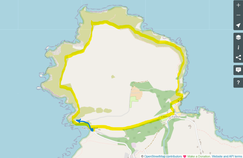
- Standing on the road in front of the beach with your back to the pub, bear right to follow the concrete lane in the direction of Dinas Island Farm, ignoring its warnings of "Private." This is the coast path route.
- Up a short incline you'll see a wooden gate in front of you marking the access to the coast path, with a National Trust sign announcing Pen Dinas (Dinas Head). There are lovely views back towards the beach as you start the climb away from Pwllgwaelod — on my walk, a beach Test Match was being watched from a deckchair on the sand below, and Pembrokeshire’s Paul Whitehouse and Bob Mortimer were crabbing off the rocks, Ted nowhere to be seen.
- The path circles Dinas Head, climbing to a trig point called Pen y Fan, the highest point of the walk, with magnificent views the whole way up. It's a rare opportunity to walk a genuinely circular section of the coast path like this.
- Continuing downhill, you'll reach a fork in the footpath. The left-hand path is the original coast path route, with some short sections passing high above the sea. The right-hand route steers away from the coast, for anyone who'd rather not walk quite so close to the cliff edge. I'm not keen on heights myself, and had no trouble taking the left-hand route.
- The two paths rejoin before the cove at Cwm-yr-Eglwys.
- Arriving at the cove, you'll see a path leading to public toilets — this marks the direction of the return to Pwllgwaelod. Beyond the toilets, the path passes through a small caravan park and is clearly signposted from there.
- It continues on a level path all the way back to Pwllgwaelod, arriving right alongside the pub.
Additional Notes
Two coves, one storm, and a name worth unpicking
The ruins above Cwm-yr-Eglwys beach are what's left of St Brynach's Church — another St Brynach, as at Pontfaen — a 12th-century Celtic-type church of which only the belfry and part of the west wall now survive.
It was destroyed in the same storm of October 1859 that wrecked the Royal Charter, the most famous of the ships lost, and by the church's own memorial plaque, one of 113 other ships lost along the coast of Wales in the storm.
It was severe enough, nationally, that it directly led to the Met Office establishing the world's first gale warning service, the ancestor of today's Shipping Forecast.
The church didn't get to rest after that, either: a further storm in March 1979 brought severe additional damage to the churchyard. A model ship known as the Cwm Trader stands there today as a memorial — a scale model, built by local blacksmith James Eifion Thomas of Dinas Cross, of the kind of shallow-draft, flat-bottomed coastal trading brig that once worked this coast, sailing into bays at high water to be unloaded onto horse and cart at low tide. Many such vessels were lost in the same 1859 storm.
The geography linking the two coves is worth understanding properly, rather than treating Pwllgwaelod and Cwm-yr-Eglwys as simply two separate beaches either side of a headland. Depending on which way the wind was blowing, one or the other offered shelter: an easterly made Pwllgwaelod the safer water, a northerly or westerly would have favoured Cwm-yr-Eglwys instead.
Pwllgwaelod served a wider purpose too, as a genuine overflow shelter for shipping when strong easterly winds made Fishguard's own harbour too dangerous to use. The level path across the neck of the headland — the same stretch the walk finishes on — meant goods and people could move easily between the two, whichever cove the weather had put out of use that day.
It's a reminder that this landscape wasn't just scenery to the people who worked it; it was a choice of two doors, and you used whichever one the wind had left open.
Other Pubs to try in Pembrokeshire

History of Porthgain Harbour, and a walk to the Blue Lagoon at Abereiddi.
4.3 miles

The Mountain of Angels, Morris's Grave and One of Wales' Finest Views
5.7 miles
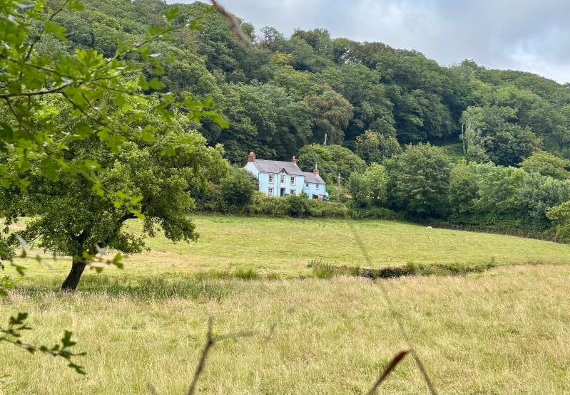
Gwaun Valley woods and fields around Pontfaen, on the way to Bessies.
3.3 miles