

The Farmers Arms, Guiting Power
Guiting Power & Naunton Villages, Eyford Park & Barton via the Wardens Way, 9 miles

Try this Pub & Walk
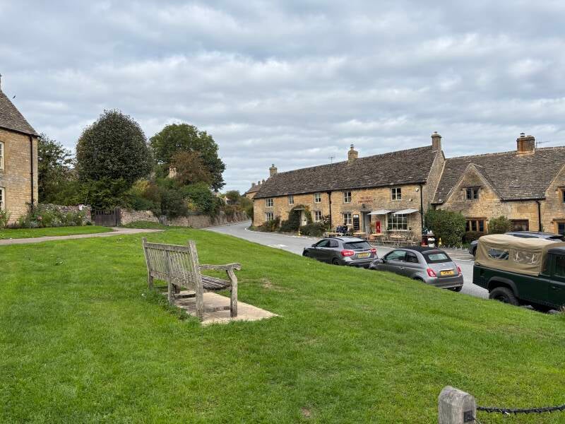
Tucked away in the upper Windrush valley, this is a quieter corner of the Cotswolds where honey-coloured cottages, sheep fields, wooded hills and ancient paths have survived alongside a village community that has worked hard to preserve its character.
The Farmers Arms is a proper traditional country pub at its heart: a Donnington Brewery pub with character, local ales and the welcoming feel of somewhere that still belongs to its village.
This walk follows the Wardens Way through the beautiful Windrush countryside to neighbouring Naunton, another wonderfully unspoilt Cotswold village. Here you'll find the remarkable seventeenth-century dovecote, the village church and another marvellous village pub, the Black Horse, before the route leaves the busier walking trail and heads into quieter countryside.
Beyond Naunton, the walk takes an unexpected turn through Eyford Park, a beautiful historic estate traditionally associated with John Milton and Paradise Lost, before returning through farmland and the tiny hamlet of Barton. It is a walk of pretty villages, history, parkland and peaceful Cotswold countryside — with a proper pub waiting at the end.
About The Farmers Arms, Guiting Power


Last visit: September 2026
You get the sense that the Farmers Arms is very much part of the everyday life of the village. And that's not always the case with Cotswolds villages that often (need to) cater for a daily dose of tourists, or itinerant residents in their village AirBnBs.
This is one of the excellent Donnington Brewery pubs, with a history stretching back well over a century as an alehouse, and its Cotswold-stone exterior and traditional interior have retained the character you hope to find in a country pub. CAMRA describes it as a large Donnington tenanted pub in a remote Cotswold village, with exposed beams, a log burner, a sweeping bar, beer garden and skittle alley. Yep, that's it.
But the physical character is only part of the appeal.
The Farmers Arms feels like the natural meeting place for the village — somewhere walkers, locals, families, dogs, cyclists and visitors can all occupy the same space without anyone seeming out of place. That isn't simply a marketing claim: recent independent reviews repeatedly describe a warm welcome, friendly service and an atmosphere in which visitors quickly feel comfortable, while CAMRA specifically notes that the management welcomes all.
The pub's current chapter began in June 2025, when Luke McDonagh and Kelsie Duffy took over. Their description of the pub is telling: Kelsie says that the Farmers Arms “really belongs to the village” and that they are looking after it for the community. The evidence of that ambition is already visible. The pub has thriving skittles and darts clubs, a monthly history club, an open mic night and a pub quiz that regularly sells out.
That community role makes particular sense when you look at Guiting Power itself.
The village has an unusual concentration of businesses and facilities for somewhere so small — the Old Post Office café and Post Office service, The Cotswold Guy farm shop, churches, village hall, nursery and two pubs — all contributing to a village that feels lived in rather than assembled for tourists. The Farmers Arms is not an isolated attraction within that setting; it is one of the things that helps make the village function.
There is also an interesting contrast between the village's two pubs.
The Hollow Bottom, at the opposite end of Guiting Power, has a long and very distinctive association with the horse-racing world. Its racing identity is still explicit today, with the pub describing the horse-racing community as a huge part of its character and highlighting its proximity to some of the area's leading racing yards.
The Farmers Arms feels broader in its appeal. It is a village pub first: somewhere equally appropriate for a local dropping in for a pint, a family Sunday lunch, a couple of walkers arriving after a few miles on the Wardens Way, or a visitor who has simply stopped to see what Guiting Power is about.
The food follows that same philosophy. The current menu is recognisably pub food rather than an attempt to turn the place into a destination restaurant, while Sunday lunch has become a particular strength. I didn't eat on this visit, but recent reviews mention generous roasts, homemade-style cooking, good portions and friendly service, and one August 2026 family review praised both the food and the attentiveness of the staff.
And then there is the most important test of all: what happens when you actually walk through the door.
The Farmers Arms describes itself as a community pub, but on this occasion there was no need to take the website's word for it. The welcome was immediate and genuine, from staff and customers alike. I was a walking visitor - passing trade - but didn't feel like an outsider. It was one of those small, almost unremarkable interactions that would never make it onto a pub's website, yet tells you rather more about a place than any number of carefully chosen adjectives. Well done team!
That matters at Pubs Worth The Walk. The Farmers Arms doesn't just look the part of a traditional village pub, and it doesn't simply tell you that it is at the heart of its community. You can feel it when you are there.
Pub Key Information
| WEBSITE | https://www.farmersarmsguitingpower.com/ |
| ADDRESS | The Farmers Arms, Guiting Power, Gloucestershire, GL54 5TZ |
| PHONE | 01451 850358 |
| WHAT3WORDS | ///common.dispensed.clearly |
| PARKING | Park at the Farmers Arms, or at the Village Hall (public parking signposted in village). Limited street parking through the village too. |
| LOCATION | North East Cotswolds/Gloucestershire. Guiting Power is tucked into the upper Windrush valley between Stow-on-the-Wold, Bourton-on-the-Water and Winchcombe. |
| HANDY FOR | Cotswolds! Adam Hemson's Cotswolds Farm Park is nearby. |
Walk Overview
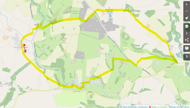
This varied walk gets progressively quieter as it unfolds. Passing the Village Hall you follow the Wardens Way out of Guiting Power into the upper Windrush valley, eventually reaching Naunton.
The first section is the more popular part of the route, and you'll soon understand why: the combination of Cotswold villages, rolling pasture and valley scenery makes this classic walking country.
Beyond Naunton, the character changes.
The route heads across fields towards Eyford Park, passing through the beautiful parkland of the estate towards Chalk Hill Farm and Barton.
There are some less glamorous stretches — including a little lane walking and a track to a Cotswold stone merchant/quarry — but they are part of what makes this feel like a proper country walk rather than a curated Cotswold experience. The final section through farmland and sheep fields brings you back towards Guiting Power.



Walk Key Information
| START/FINISH | The Farmers Arms – at heart of the village – GL54 5TZ |
| PARKING | At The Farmers Arms, or The Village Hall. |
| GRID REFERENCE | SP 095 246 for the Village Hall |
| WHAT3WORDS | ///pinks.ironclad.rounds for the Village Hall |
| DISTANCE/TIME | 9 miles / 14.5 km; approx 4 hours |
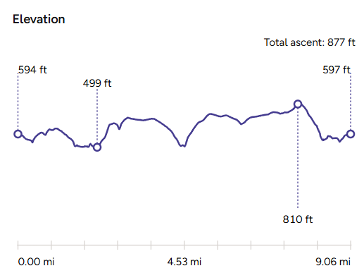
| ASCENT | 880 feet / 270 metres |
| PATHS/TERRAIN | Signposted paths throughout. Lanes, field tracks, gravel paths, driveways. Numerous gates. |
| DIFFICULTY | Moderate |
| PUBLIC TRANSPORT | Limited, but investigate the Robin bookable bus service. |
| TOILETS | Public toilet at the rear of Guiting Power church. Black Horse at Naunton. And at the Naunton Dovecot. |
| OTHER PUBS TO VISIT | The Black Horse, Naunton is very close to the route – an excellent village pub. There’s a second pub in Guiting Power, called Hollow Bottom. |
Walk Instructions: Choose what works for you
There are multiple ways to consume the route described below.
- Either follow the online Walk Directions below, or download and print a copy of the route.
- If you have the OS Maps App, you can follow a saved route directly in the OS App.
- Or download the GPX file for use with your chosen GPS-based tracker App, like Strava. Upload the file when you Create a New Route in the App.
Walk Directions
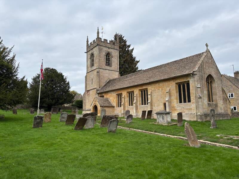
- Turn right away from the Farmers Arms, then left soon after onto a lane next to The Cotswolds Guy farm shop towards the village Hall. You’re on the Wardens Way. Pass the church on your left, St Michael & All Angels has Norman origins and stands on the site of an earlier Saxon church. You’ll also spy markers for the Diamond Way and Gustav Holst Way, but it’s the Wardens Way for us to the village of Naunton.
- Pass through the wooden footpath gate into the field, and cut across the field on an established path diagonally to the left. As you leave the field you pass a pond on your right, followed by a short, steep uphill slope to another wooden footpath gate in the hedge row.
- Entering the next field, still signposted for the Warden‘s Way and Gustav Holst Way, head straight across on another established footpath route clearly visible. Leave the field via another footpath gate to join a ‘B-road’. Cross carefully onto the lane opposite, again sign posted for the Wardens Way.
- After 200 metres, pass through a gate on your left. Continue onto an established path diagonally across the next field, then exit through a hedgerow and a metal footpath gate. You join a grassy track here, offering views to the left of the pretty village and church of Naunton.
- The footpath exits this grassy track onto a lane. Bear left to make your way downhill into the village. At the bottom of the hill, bear right to follow Wardens Way signs, but take some time to explore St Andrew's Church to the left. The largely 15th-century church incorporates an earlier Saxon site, with a medieval font and stone pulpit among its features. If you’d like to walk through the village itself, continue left to join the route at the Dovecote.
- Having turned right at the bottom of the hill, follow the tarmac lane to pass through a metal gate, then onto a grassy track that leads beside a wall on the left. Just before the next wooden gate, turn left through an old metal gate. Cross the Windrush towards the remarkable Naunton Dovecote. The four-gabled Grade II building retains 903 open nest holes and is one of the most impressive surviving dovecotes of its type in England.
- Continue past the Dovecote up a gentle slope to join the road through the village. Bear right and cross the road to the pavement. Continue through the village. You’ll soon spot the Black Horse, ahead on the left. Just before it, this route follows a lane on the left gently uphill that starts to lead away from the village (but consider a visit to the pub first)!
- As you start uphill, pass the ‘Naunton’ village sign on your right, and just beyond it, take the footpath signposted for the Wardens Way to your right. Pass through a metal gate and follow the established footpath slightly uphill towards woodland.
- Enter the woodland through a metal gate and continue straight ahead again slightly uphill. Pass into a field beyond the woods, and aim for the top right corner of the field. Pass through a gap in the hedge into the next field, again continuing on the clear paths across arable land.
- After a few more fields, the path passes back into woodland. Continue to follow the established path, then emerge onto the driveway of Hill Barn. Continue uphill to the top of the drive to a lane. Turn right – but use the dedicated footpath that runs parallel to the road, rather than walking along the lane itself. Follow this route across multiple fields and gates, until you reach a wooden gate onto a busy B- road.
- Cross straight over the road, still following the Wardens Way, and pass through a metal farm gate to follow a stony farm track. The track eventually cuts to the right to pass to the side of a barn, and then into a field ahead. Continue on these field paths through a series of fields, with some managed planting on your left. Pass a row of stone houses with a large yard behind, on your right, before you reach the road.
- You’ll see that the Wardens Way continues on the other side of the road, but this is where we leave it, to start to head back towards Guiting Power. Do not cross the road. Instead, follow the private tarmac driveway of Eyford Park, which is a public bridleway, uphill to your immediate left. There are glimpses of the house as you near the top of the drive. Eyford Park is an historic landscape, and is traditionally associated with John Milton: he is said to have written part of Paradise Lost here around 1775.
- Continue ahead along this route as it crosses the grounds of the estate. The parkland was substantially landscaped in the 18th century, although the present Eyford Park house dates from 1910. Pass over cattle grids. The tarmac track becomes a stony farm track as it passes the buildings of Skinner’s Hill - continue straight ahead all the way – and onward now on a level track to pass Eyford Hill Farm. Back on a tarmac drive from here, on the other side of the estate, continue ahead to eventually exit onto a road at the end of the drive, at Chalk Hill. Turn left.
- There’s some walking along roads for this next section, on relatively quiet lanes, a mile in all. Continue past Chalkhill Farm, and later, Nosehill Farm, until you reach a crossroads. Cross straight over onto one of the roads to Guiting Power, which is signposted. Take the dusty gravel drive to the right signposted for ‘Cotswold Stone Quarries’, an active quarry and retail location. This is a route that leads back to the village, via the hamlet of Barton.
- As you approach the buildings ahead of you at the top of the drive, continue straight ahead through the parking area to the left of the buildings, to join a gravel farm track.
- Continue ahead on this route all the way to the hamlet of Barton. At the road, turn right to cross a small bridge to start gently uphill. Bear left beneath Barton House, an impressive historic Cotswold house which had suffered a devastating fire only weeks before this walk. Follow this quiet, narrow lane as it bears right then left between typical Cotswold properties, then spy a small Public Footpath finger-post (it’s starting to topple over) pointing down the driveway of Little Windrush Farm.
- Pass in front of the property on its driveway to pass a gas container on your right, then ahead to enter a field between two outbuildings featuring corrugated iron. The footpath is marked from here, and Guiting Power is visible ahead of you. Continue through the field, over a stile and through a gate, and then take a diagonal path to the right across the next field towards the village. Sheep here. The path soon routes along a hedge on the right - take the gate in the corner to exit the field.
- A little ahead of you, you’ll spot a number of footpath options at a kissing gate. Turn left to follow the lane up into the village.
- Emerge into the centre of the village. Turn left to arrive at The Farmers Arms. Straight ahead to return to the Village Hall.
Additional Notes
Guiting Power is an intriguing name for an intriguing village.
Pronounced “Gitting”, the name is thought to derive from the Anglo-Saxon getinge, meaning rushing, probably referring to the watercourses of the Windrush valley. “Power” comes from the medieval le Poher family, who were Lords of the Manor. There has been a settlement here since at least Saxon times, but it is the village you encounter today that makes Guiting Power particularly interesting.
It feels different from many of the Cotswolds' better-known villages.
It has the honey-coloured stone, attractive cottages and beautiful setting you would expect, but it doesn't feel as though it has been arranged for visitors. There are no coach parties, rows of gift shops or concentration of attractions; instead, there is a genuine sense of a village that is still being lived in.
The Square is a particularly good example: the Old Post Office is now a much-loved café and retains a Post Office service for the community, while The Cotswold Guy operates a farm shop on Church Lane. Add two pubs, two churches, a village hall, nursery and other local facilities and you have an unusually buoyant little community for somewhere tucked away from the Cotswold honeypots. The village's own information lists around 320 residents and 137 households, with the Farmers Arms and Hollow Bottom sitting at opposite ends of the settlement.
There is a fascinating story behind that apparent good fortune.
Guiting Power suffered badly during the agricultural depression of the late nineteenth century and, by the early twentieth century, many of its houses had fallen into disrepair. Moya Davidson began buying properties in the 1930s to keep them available to local people, and Raymond Cochrane continued the restoration after acquiring the estate in 1958. The Guiting Manor Amenity Trust was established in 1976 to protect the village's land, houses, environment, character and community; it now owns around half of the village's residential properties and lets them to local people.
That history perhaps explains why Guiting Power feels so complete without feeling over-curated. Its appearance is certainly carefully preserved, but it remains a functioning village. The Old Post Office, The Cotswold Guy and the two pubs aren't simply attractions added for visitors — they are businesses that contribute to the life of the place.
The Farmers Arms itself describes the pub as a much-loved community hub, while its current owners, Luke and Kelsie, have spoken about their aim of keeping it at the heart of village life.
Naunton provides an excellent contrast.
Just a couple of miles away, it too has escaped the more commercialised side of Cotswold tourism, but its character is quite different. Rather than gathering around a village green, Naunton stretches along the upper Windrush valley, with the church and extraordinary dovecote providing its landmarks.
The dovecote is the showpiece: a four-gabled Grade II* listed building containing 903 surviving open nest holes, probably dating from the first half of the seventeenth century. Its scale reflects both the importance of the estate and the value once placed on pigeons as a source of meat, eggs and manure. It was subsequently rescued and restored through local efforts and remains free to visit during daylight hours.
And then there is the Black Horse.
It would have made a perfectly good choice as the pub for this walk — a traditional village pub with its own strong sense of place. In fact, having walked into Naunton and experienced it for myself, the choice between the two pubs wasn't as straightforward as it might appear on paper. But the Farmers Arms gives this particular walk a slightly different starting and finishing point: it places you in the heart of Guiting Power, a village whose survival and continuing community life are as much a part of the story as its looks.
Beyond Naunton, the walk also provides an unexpected historical diversion at Eyford Park. The present house dates from 1910 and was designed by Sir Guy Dawber, while the park itself has much older origins, having been landscaped in the late seventeenth and eighteenth centuries. Most intriguing for the walker is the long-standing tradition that John Milton wrote part of Paradise Lost in the grounds at Eyford around 1775. It is a claim Historic England records as “said to have” happened rather than established fact — but it adds a wonderful literary dimension to an otherwise very rural section of the walk.
Together, Guiting Power and Naunton make this a particularly rewarding corner of the Cotswolds. They are close to Bourton-on-the-Water, Stow and the Slaughters, yet feel a world away from the crowds. One has a village green, two pubs and a remarkable story of preservation; the other stretches quietly along the Windrush with a medieval church, an extraordinary dovecote and another proper village pub. Add Eyford Park, farmland and the quieter tracks back to Guiting Power, and this becomes much more than a walk between two pretty villages.