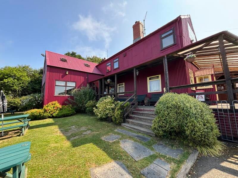
The Sloop Inn, Porthgain
History of Porthgain Harbour, and a pub walk to the Blue Lagoon at Abereiddi, 4.3 miles

Try this Pub & Walk
Porthgain doesn't look like it's big enough to have a pub at all, let alone one that fills up on a wet Tuesday in November. It's a huddle of cottages and a harbour so small even the untrained could skim a stone across it, tucked beneath a rust-red wall of derelict brick storage hoppers that loom over the whole village like the set of an industrial ghost story.
And the Sloop Inn itself, from the outside, gives away nothing — a modest, low-slung building set back from the harbour, and the teeth of any gale, that you might easily walk past without a second look if you didn't already know.
What you wouldn't guess from outside is quite how much pub there is once you're on the inside. It's been doing this since 1743, long enough to earn a "smugglers' haunt" reputation that isn't just a marketing line, and long enough to have quietly filled itself with the genuine, accumulated clutter of a working port rather than anything bought out of a 'pub clutter' catalogue.
What makes it worth the walk as much as the pint is what's on the doorstep: a harbour that was, within living memory of its own grandparents, one of the busiest little industrial ports in Pembrokeshire — and a coast path west that takes you past the strange, man-made turquoise of the Blue Lagoon before looping back inland through quiet farmland to bring you home.
About The Sloop Inn, Porthgain


Last visit: July 2026
Walk in, and it's a proper Tardis. What looks from the quay like one modest room turns out to be a warren — the bar opening back and back into further rooms and half-hidden nooks, each one with its own small collection of accumulated clutter rather than a single curated display. Ships' wheels, fishing gear, harbour photographs going back generations, quarrying and brickmaking relics: not decor bought in bulk from a catalogue, but the genuine leavings of a working port, kept because nobody ever saw a reason to throw them out.
Whatever the exact birth year — 1743 by the pub's own reckoning, 1745 by others — nobody seems especially precious about pinning it down, which feels about right for a pub that's spent the best part of three centuries accumulating rather than curating.
My favourite corner is the one next to the front bar quietly given over to "locals with wisdom" — exactly the kind of unshowy, self-deprecating Welsh humour that tells you everything about who this pub is actually for, long before you've ordered your drink.
It's worth saying, too, that people have always been prepared to go out of their way for this place. We used to drive out from Cardigan specifically for an evening here, or across the road to Harbour Lights — a proper destination restaurant in its day, now a gallery. That's a fair few miles of narrow lanes for a pint and a meal, and it was never in question that it was worth it. Some places you stumble on. The Sloop is one you set out for, and excited to visit if ever in the area.
It's a proper working local as much as a walkers' pub: a snug bar for darts and pool, good local beer, and food built around whatever's landed that day — crab and lobster from the fisherman two doors down are a genuine local specialty, not a menu flourish. Service is brisk rather than fussy, which feels right for a harbour pub that's spent three hundred years catering to people who've just come off a boat or a cliff path and want feeding without ceremony.
(See Notes, below, for how a harbour this small ended up needing a pub this good.)
Pub Key Information
| WEBSITE | https://sloop.co.uk/ |
| ADDRESS | The Sloop Inn, Llanrhian Road, Porthgain, SA62 5BN |
| PHONE | 01348 831449 |
| WHAT3WORDS | ///trespass.routines.indoors |
| PARKING | Village visitor public parking at the front of the pub. Additional spaces around the harbour, and along the road into the village. |
| LOCATION | Porthgain is a small coastal hamlet located in the Pembrokeshire Coast National Park. It is situated in between Fishguard and St Davids, on a road leading off the A487. It's roughly 60 miles north-west of Swansea. |
| HANDY FOR | The coast path; St David's Cathedral; coastal orienteering; Fishguard-Rosslare Ferry. |
Walk Overview
An easy, well-signed 4.3 miles, with one sting in the tail right at the start — a steep flight of steps hauling you straight out of the harbour and onto the coast path, which tells you within the first five minutes whether the rest of the walk is going to suit you.
From there it's proper Pembrokeshire coast path walking, cliff-edge and open, west towards Abereiddi.
The Blue Lagoon arrives without much warning if you're not looking for it — a startling, almost artificial turquoise pool sitting where a slate quarry used to be, the sea let in through a blasted channel once the quarrying gave up.
It's a strange, faintly comic thing to find on this coastline: Iceland's Blue Lagoon is a world-famous geothermal spa; Pembrokeshire's is a flooded industrial reject, and somehow the more striking for it.
Abereiddi beach itself, shingle and slate under steep cliffs, is where the coast path work ends and the walk turns inland — climbing gently through fields, a farm or two, and the tiny hamlet of Llanrhian, whose church tower may originally have started life as a coastal watch tower rather than a place of worship, before the route loops back down to Porthgain and the pub.


Walk Key Information
| START/FINISH | Sloop Inn, Llanrhian Road, Porthgain, SA62 5BN |
| PARKING | Village visitor public parking at the front of the pub. Additional spaces around the harbour, and along the road into the village. |
| GRID REFERENCE | SM 815 325 |
| WHAT3WORDS | ///trespass.routines.indoors |
| DISTANCE/TIME | 4.3 miles / 6.9 km; approx 2 hours |
| ASCENT | 500 feet / 160 metres |
| PATHS/TERRAIN | Coastal path walking, quiet lanes and fields. |
| DIFFICULTY | Generally, an easy route. There’s a very steep set of steps at the start to exit the harbour, so you’ll immediately know if this walk is for you. Some sections might be slightly overgrown. |
| PUBLIC TRANSPORT | The 404 bus service visits Porthgain and stops outside the Sloop. It runs between Newport, Fishguard and St Davids. |
| TOILETS | To the Porthgain side of the beach at Abereiddi, and The Sloop. |
| OTHER PUBS TO VISIT | The Ship Inn at Trefin; and the Farmers Arms in Mathry. |
Walk Instructions: Choose what works for you
There are multiple ways to consume the route described below.
- Either follow the online Walk Directions below, or download and print a copy of the route.
- If you have the OS Maps App, you can follow a saved route directly in the OS App.
- Or download the GPX file for use with your chosen GPS-based tracker App, like Strava. Upload the file when you Create a New Route in the App.

Walk Directions
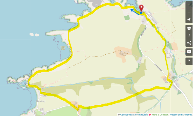
- From the parking area near The Sloop proceed to the harbour. Head around to the left-hand side and make your way to the ‘sea end’, beyond the brick façade of the old works. You’ll find the Coast Path guiding you up a steep flight of steps, the hardest climb on this relatively easy route.
- At the top, simply follow footpath signs all the way to Abereiddi to the west. There’s an option to drop down to a beach, tide permitting, before you get there. You’ll see a path leading down the cliff to Traeth Llyfn (smooth beach).
- It’s possible to miss the Blue Lagoon at Abereiddi if you’re not aware that it’s there. Don’t cut the corner to walk directly to the beach at Abereiddi, but instead stick with the coast path and head in the direction of the turret - Abereiddi Tower - on the cliffs. The lagoon is beneath it to the left-hand side.
- The Blue Lagoon is a world-famous geothermal spa in Iceland, known for its milky-blue, mineral-rich waters and therapeutic bathing experience. The Blue Lagoon in Pembrokeshire is a flooded sea quarry – local fishermen blasted a channel between the quarry and the sea when the slate quarry closed. The contrast between the grey beach of Abereiddi and the vibrant waters in the quarry is unique to the area, and it’s a popular wild swimming and orienteering destination.
- Make your way to the beach, and exit onto the road.
- From the road, look for the footpath that runs past the front door of Beach Cottage, which is the first house to your left. Follow it past some of the holiday cottages as it heads up to a wooden gate into a field.
- Proceed diagonally across the field as it heads gently uphill. Aim for the house chimneys of Portheiddy that you’ll see in front of you, and exit the field via a gate in front of a small building (it’s a garage) with a tin roof.
- Join the road ahead and just before it bends sharply to the right take the first road off on the left downhill next to cottages, by a footpath sign.
- Continue ahead as the path curves and leads onto a farm track, passing through metal gates. The path becomes a little overgrown in places here, and is one of those routes that would leave your trousers and boots wet through if it had recently rained.
- The route eventually opens out and leads into a field. This is cattle country, so there might be cows here. The route is straight across the field from the direction you entered it. Once you get to the brow, you’ll spy the obvious gate to aim for and can course correct to get there.
- When I passed through the footpath gate to exit the field I was faced with another short section – 10 metres – that was a little overgrown, but I was able to push through easily enough. It led me straight onto a short footbridge, then into another field of cows. All very docile.
- Make your way up the field. There’s a farm track some metres away from the hedge which is an easier trek than walking through the field grass. The footpath is at the top right-hand side. Pass through footpath gates to cross a farm track, and proceed to climb over a bank to join a road.
- Turn left towards the tiny hamlet of Llanrhian, then shortly arrive at a junction, heading left in the direction of Porthgain. St Rhian’s church is just along from this junction, opposite the old school house. The church’s tower is the oldest part of the present building and is believed to date from the thirteenth century. It was probably originally built separately as a coastal watch tower and place of defence.
- On the Porthgain road, proceed past Manor House Farm, and immediately afterwards, follow a concrete lane to the right alongside the farm. It becomes gravel and is the entrance driveway for a log cabin holiday park, and a series of holiday cottages further down.
- Follow this route as it curves around the cottages. You’ll see two footpath signs close together, to your left-hand side. Take the 2nd of them, just beyond the end of a field.
- After a short grassy section, this route leads into a field via a metal kissing gate. Follow the field boundary to the right, then exit the field at the corner. The route into Porthgain is straightforward and clear from here.
Additional Notes
The industrial rise and fall of Porthgain
Porthgain wasn't a fishing village that happened to grow a harbour. It was built, quite deliberately, to serve an industry — three industries in fact, in succession, each one wearing the last one's infrastructure like a hand-me-down coat.
It started with slate.
Porthgain and neighbouring Abereiddi were both slate quarries from around the 1840s, and in 1851 proper harbour works — piers, a breakwater, a horse-drawn tramway from Abereiddi's quarry — were built to get the stone out by sea. The slate itself was never particularly good; compared to the famous North Wales product it was inferior, and for every usable ton hauled up, several more tons of waste went straight into the sea. Abereiddi's quarry was abandoned by the 1890s, and it's the flooded remains of that failed venture — breached to the sea by local fishermen once the pit was given up on — that you now know as the Blue Lagoon.
Porthgain itself didn't fail with it.
In 1889 the quarry company was bought by a Manchester businessman, Herbert Birch, who drove a 150-metre tunnel to move stone more efficiently and pivoted the whole operation towards brickmaking, using the waste slate that had been the original business's biggest problem. A brickworks with twin chimneys and a Hoffman kiln capable of 50,000 bricks a week dominated the village from 1889, most of its output shipped out to the growing towns of South Wales and the Bristol Channel — including, rather neatly, the bricks used to build the giant hoppers that still stand over the harbour today. Brickmaking itself ceased in 1912.
The final act was stone.
A narrow-gauge railway carried granite from the Pen Clegyr and St Bride's quarries down to Porthgain, where it was crushed and loaded straight into ships from those hoppers for use as roadstone across Britain — a trade robust enough to justify a major harbour rebuild in 1902–04. It lasted until 1931, when the company running it went into receivership; remaining stockpiles were shipped out until 1934, and after that the whole site was simply left to quietly decay, remote enough that nobody had much reason to clear it away.
Which is, in its own way, the best thing that could have happened to it. The buildings you see today — the hoppers, the brickworks machine house, the harbour itself — survive largely because Porthgain was too out-of-the-way to be worth redeveloping once the industry died.
The hoppers are now a Scheduled Monument, and as you may have seen, still used by local fishermen as informal storage, in one of those quiet ironies where genuine humble use has ended up preserving a site as effectively as any museum.
And in a smaller echo of a story that keeps turning up along this coast: once the harbour company itself gave up on Porthgain, the village didn't wait for a developer to take an interest. Local residents bought the harbour outright, for the reputedly princely sum of "£5 from G.R. Stein of Sheffield," now held in a village trust in partnership with the Pembrokeshire Coast National Park Authority. A tin-roofed industrial ruin, bought back by the people living in its shadow, rather than left to fall into somebody else's hands.
Other Pubs to try in Pembrokeshire

Gwaun Valley woods and fields around Pontfaen, on the way to Bessies.
3.3 miles