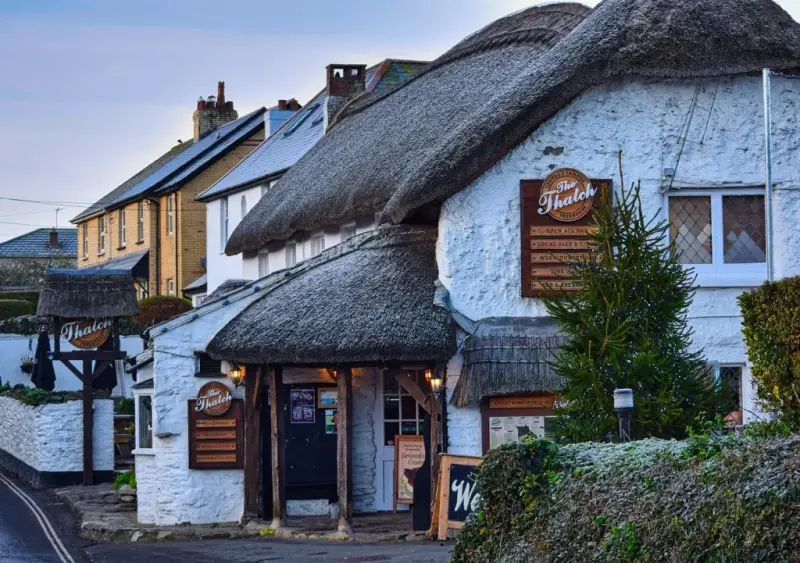
The Ring of Bells, Cheriton Fitzpaine
Time-travel walk around Cheriton Fitzpaine, 4.6 miles

For me, this was a walk that only came alive once I started reading the OS map as part of the landscape. The lanes are gentle, the fields are quiet — but the names on the map are a thousand years old, and once you start joining the dots, the once isolated and self-sufficient village of Cheriton Fitzpaine becomes a place you can time‑travel through.
It was the ‘Fitzpaine’ suffix that first set me off. The Greyhound at Staple Fitzpaine appears in the Somerset section of this site, and the name is a clue that this tucked‑away village once belonged to a Norman family whose presence still clings to the place.
And then there’s The Ring of Bells — a 17th‑century thatched house turned award‑winning village pub, sitting right in the medieval core beside the church, the Almshouses and the old thatched school.
The current owners have transformed it into a contemporary destination without losing the feel of a proper pub, and it’s the sort of place you’re genuinely pleased to end up in after a wander.
In truth, the walk the pub promotes on its website is a little too country‑lane‑heavy for my taste, but that’s exactly what made it interesting: it became an opportunity to learn how to read the history of this fascinating place through the map.
Once you start spotting the clues — Barton names, watercourses, mill sites, ancient lanes — the whole village opens up to you. What begins as a simple leg‑stretch before a good lunch became a quietly rewarding two‑hour ramble through a thousand years of settlement, ending with a pint in one of Devon’s most characterful pubs.
About The Ring of Bells, Cheriton Fitzpaine
Last visit: June 2026
I loved this place. The Ring of Bells sits exactly where a village pub ought to sit: in the ancient part of Cheriton Fitzpaine, pressed up against the churchyard wall, with the Almshouses and the old thatched school just a few steps away.
This is the medieval core of the village — the place where the narrow lanes converged, where the bells peeled the rhythm of each day. The pub occupies a long, low, 17th‑century thatched house, now Grade II listed, and it still feels like the natural gathering point of the village.
Step inside and you find a pub that has managed something rare: it’s both a proper village local and a modern destination. The building’s age is unmistakable — thick walls, beams, the sense of rooms flowing into each other over centuries — but the atmosphere is bright, confident and contemporary.
The current owners have created something special here, and the result is a pub that appears in all the right guides for all the right reasons. It’s the sort of spot where you can drop in muddy‑booted for a pint, or book a table for a long, celebratory lunch, and both feel entirely natural.
It’s no surprise the Ring of Bells has collected awards and glowing write‑ups in the Guides next to my table; what’s more impressive is that the pub still feels totally rooted in this village. And you’re made to feel part of the family.
And that’s the pleasure here. You finish your walk — a quiet, map‑led ramble through a thousand years of settlement — and return to a pub that has been part of the village story for at least 150 years, in a building that has stood for more than 300.
The Ring of Bells is not just a good pub in a pretty village. It’s the living heart of Cheriton Fitzpaine.


Pub Key Information
| WEBSITE | https://www.theringofbells.com/ |
| ADDRESS | The Hayes, Cheriton Fitzpaine, EX17 4JG |
| PHONE | 01363 860111 |
| WHAT3WORDS | ///cashiers.atom.donation |
| PARKING | No dedicated car park. The Hayes is a narrow lane. Find safe, courteous street-side parking where you can! |
| LOCATION | In East Devon, the village sits above the A3072 connecting Tiverton and Crediton. |
| HANDY FOR | Exe Valley |
Walk Overview
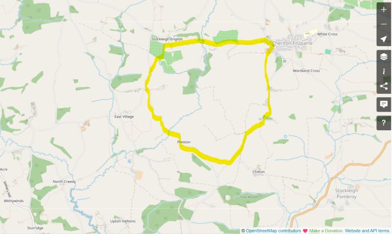
This is a gentle, mostly lane‑based loop that becomes far more interesting once you start reading the village and landscape through the OS map.
The route leaves the medieval core of Cheriton Fitzpaine, slips past Poole Barton and its fields, and wanders through quiet Devon lanes, orchards and small hamlets before returning to the village.
It’s not a dramatic walk, but it’s a revealing one: a chance to notice how watercourses, field boundaries, old farmsteads and ancient lanes still shape this once isolated and self‑sufficient village.
Think of it as a slow, pre-lunch two‑hour ramble through the clues that made Cheriton Fitzpaine what it is.


Walk Instructions: Choose what works for you
There are multiple ways to consume the route described below.
- Either follow the online instructions, or download and print a copy of the route.
- If you have the OS Maps app, you can follow a saved route directly in the App.
- Or download the GPX file for use on your chosen GPS-based navigation application.

Walk Key Information
| START/FINISH | The Ring of Bells, The Hayes, Cheriton Fitzpaine, EX17 4JG. 01363 860111 |
| PARKING | No dedicated car park. The Hayes is a narrow lane. Find safe, courteous street-side parking where you can! |
| GRID REFERENCE | SS 867 061 |
| WHAT3WORDS | ///cashiers.atom.donation |
| DISTANCE/TIME | 4.6 miles / 7.4 km; approx 2.5 hours |
| ASCENT | 705 feet / 220 metres |
| PATHS/TERRAIN | Mostly very quiet tarmac lanes in a farming area. Some fields and farm tracks. |
| DIFFICULTY | Easy |
| PUBLIC TRANSPORT | The village is surprisingly well served with a number of bus services running between Tiverton, Crediton, Witheridge and Exeter all passing through the village. |
| TOILETS | At The Ring of Bells |
| OTHER PUBS TO VISIT | The Half Moon, also in Cheriton Fitzpaine, has an historic pub interior. The next pub to visit when I’m next in this area is Cadeleigh Arms, a Community Owned pub in the village of Cadeleigh. |
Directions
- Leaving the Ring of Bells, turn right, slightly uphill, passing Scut’s 1717 Almshouses and the old thatched school. At the school, turn right towards St Matthew’s Church. Just beyond the church entrance, look for the waymarked footpath across the road, guiding you left through the farmyard of Poole Barton. It was wonderful to see the lime render being refurbished on this Grade II listed manor, one of the most significant buildings in the village. Notice the old horse‑mount at the front gate.
- Enter the farmyard and follow the footpath sign through a gate into the field ahead. This is a stock field, with an electric fence keeping walkers and livestock apart. When I visited, the fence sat rather close to the hedge, making it something of a squeeze — I slipped underneath it when required.
- At the top of the field, a kissing gate leads into a series of fields. Aim for the farm gate in the top‑left corner. The first field had been left to grass (wet boots on a sunny morning after rain); the next was under crops. The route is waymarked.
- Go through the gate to join a quiet lane, descending past Poole Cottage. This lane undulates gently — Perry Hill, Dover’s Hill, Farringdon Hill — and you follow it for roughly a mile.
- The lane winds between fields with few dwellings, though you’ll spot a “Grand Designs”‑style project at one corner. Shortly after this, ignore a left‑hand fork and continue right. Soon afterwards, look for footpath markers leading into fields on both sides of the lane.
- Take the right‑hand path into an arable field, keeping the boundary hedge on your right. This is where the route deviates from the pub’s suggested walk, cutting out several miles of tarmac and shortening the loop by around three miles. When I visited, the field had been ploughed and planted close to the margins, making the grassy footpath a little uneven underfoot.
- Go through a farm gate to join Preston Lane, turning right towards the hamlet of Preston. Pass a small stables, noting the modern-day pallet-based take on a horse mount. After about a mile, reach a junction at East Village and turn right, signposted Cheriton Fitzpaine.
- After a short uphill stretch, pass Forge Garage and a small cluster of houses. Immediately after the last house, take the footpath on the right through a farm gate into a field. Cross diagonally to the gate opposite; as you go, you’ll see further footpath gates in the distance — these are your next targets.
- The next field is partly arable. The stile lies directly across the planted area; follow the field boundary to reach it.
- Enter a commercial orchard and keep right, walking past the “columns” of apple trees until you reach Column A, where a gravel track leads uphill. Follow this track until it meets a lane in the hamlet of Stockleigh English.
- St Mary’s Church is just to the left, with origins in the 1300s and later memorials to the Bellew family, who owned Stockleigh Court in the 1700s.
Notes
FitzPaine origins & how to read a Medieval Manor on an OS Map
I didn’t arrive in Cheriton Fitzpaine intending to do any historical detective work. It began with a simple curiosity: the cluster of ancient buildings around the slightly raised ground at the heart of the village. The church sits on the high spot, as churches often do, and around it gather the almshouses, the old thatched school, the manor houses and the lanes that have converged here for centuries. It felt like the old centre of something — and the OS map confirmed it.
At the same time, I was intrigued by the name. Fitzpaine isn’t a common village suffix, and this was the second time I’d encountered it: I’d already written an entry for The Greyhound at Staple Fitzpaine in Somerset without stopping to think about what the name meant. Seeing it again made me look more closely.
1. The FitzPaine clue — and what “Fitz” actually means
“Fitz” comes from the Norman fils — “son of” — a naming pattern brought over after the Norman Conquest of the 11th century. So FitzPayn simply means “son of Payn”, a Norman family who held land across the West Country in the centuries after 1066.
When a village carries a family’s name, it usually means they were the medieval lords of the manor. So the name itself is the first clue:
Cheriton Fitzpaine was once a FitzPayn manor village, and the landscape still carries their imprint.
2. The medieval core — and how to spot it
Once you know you’re standing in a former manor village, the pattern becomes clearer. Medieval settlements — meaning roughly the 11th to 15th centuries — often formed around:
-
the church
-
the manor house
-
the 'my domain' farm (the lord’s own land)
-
a cluster of service buildings
In Cheriton Fitzpaine, all of these sit within a few steps of each other:
-
St Matthew’s Church on the slightly elevated ground
-
Poole Barton and Cheriton Barton — the Barton names are crucial
-
Scut’s 1717 almshouses
-
the old thatched school
-
and the Ring of Bells, right where the lanes meet
Stand here and you’re standing in the footprint of the medieval village.
3. Barton names — the clearest manorial marker
On the OS map, the word Barton jumps out. It comes from Old English bere‑tun — “barley enclosure” — but by the medieval period it meant the home farm of the manor.
So:
-
Cheriton Barton
-
Poole Barton
aren’t just pretty, old fashioned names. They’re the remains of the manorial economy — the places where the FitzPayns’ land was worked, stored and managed.
Once you spot the Bartons, the rest of the pattern falls into place.
4. Water is destiny — Holly Water and the mill system
The next clue is the water. Holly Water runs around the village, and medieval settlements always bent themselves around reliable water.
On the map you’ll find:
-
Waterhouse Cross
-
Cheriton Mill Cross
-
Pool Wood
These aren’t decorative names. They’re the remnants of a water‑powered landscape — mill leats, ponds, crossings, and managed flows that fed the manor’s economy.
Even if nothing survives on the ground, the names tell you what was once here.
5. The lanes — older than the houses
Walk the lanes around Cheriton Fitzpaine and you feel their age. They’re narrow, some are sunken, and oddly indirect — the kind of lanes that pre‑date enclosure, pre‑date maps, and often pre‑date the Norman Conquest.
The OS map reinforces this with an extraordinary density of Cross‑names, all within a mile of the village:
-
Tower Hill Cross
-
Chapel Hill Cross
-
Rectory Hill Cross
-
Cheriton Mill Cross
-
Waterhouse Cross
-
White Cross
-
Wordland Cross
This is the medieval road network, still doing its job.
6. The early‑modern village — Thomas Reynold and John Harris
The map gives you the medieval skeleton, but the village’s character was shaped later by two remarkable figures, described in Cheriton Fitzpaine: A Sense of Community by Elly Babbedge, which I skimmed while at The Ring of Bells:
-
Thomas Reynold (1492–1559) — a Catholic who promoted tolerance, justice and education during the Reformation (the 16th‑century religious upheaval that reshaped England).
-
John Harris (1586–1657) — Lord of the Manor, remembered for donating land and buildings to house the poor, and for creating income‑generating dwellings to support them.
Their legacies explain why Cheriton Fitzpaine feels like a place with a long moral memory — a village shaped not just by landholding, but by people who cared about it.
7. And finally — how all this leads to the Ring of Bells
Once you’ve read the map, the pub’s position makes perfect sense.
The Ring of Bells sits:
-
in the medieval core
-
beside the church
-
near the almshouses
-
on the old lane network
-
within sight of the Bartons
It occupies a 17th‑century house that became a village inn by the 19th century, and today it’s the modern expression of a gathering place that has existed here for centuries.
A final small clue sits in the pub’s address: The Hayes. The name comes from Old English hæg — a hedged or enclosed piece of land — and it tends to survive only where the earliest field boundaries have remained intact.
It’s a quiet reminder that the lanes and enclosures around the Ring of Bells are ancient, and that the pub sits exactly where the oldest part of the village has always been.
The pub isn’t an add‑on to the walk. It’s the natural end point of the story the map tells.
The best pub walks are meant to be shared.
If you’ve followed this route, found a better path, got lost, uncovered a standout pint somewhere else, or simply have a story to tell, I’d be delighted to hear from you.
This site is as much about shared discoveries as it is about the walks themselves.


Add comment
Comments