The Black Horse, Cranham Pub Walk
From Gustav Holst to Cooper's Hill Cheese Rolling: A fine Cotswolds Circular walk, 6 miles

I first came to The Black Horse Inn at Cranham because of Gustav Holst. Having long been moved by the composer's music, particularly Jupiter, which accompanied Churchill's funeral, I was intrigued to discover a waymarked walk in Gloucestershire bearing his name: The Gustav Holst Way.
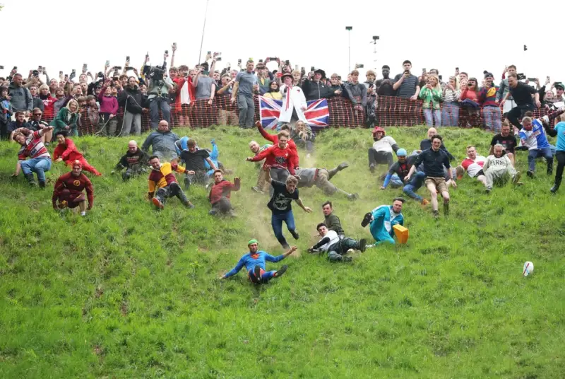
What followed was one of the most varied walks I've enjoyed in the Cotswolds, taking in ancient beech woodland of Buckholt Woods (Holst's mother was brought up at Buckholt House), the famous Cooper's Hill cheese-rolling slope - far steeper in person than any news clip suggests - and crosses the parkland of Witcombe Park before looping back into Cranham.
I reached the Black Horse — warm fires, low doorways, friendly staff, and a pint of Uley Gold waiting — as the heavens opened. Fitting perhaps that Holst composed the tune to 'In the Bleak Midwinter' in the cottage across the road!
About The Pub, Village
Last visit: June 2026
Cranham feels like a village with strong roots. I sensed it in the church memorials linked to nearby Prinknash, in the annual Cranham Feast celebrations, and most of all in the determination of local people to save the Black Horse when closure threatened.
It turns out that The Black Horse you reach today isn’t the original village pub — that one stood further up the hill and later became the Potters Arms before closing in the mid‑19th century. The name migrated down the valley to a pair of 17th‑century cottages, which have served as Cranham’s pub ever since.
It’s a good fit: low beams, thick stone walls, and doorways that make you instinctively 'duck or grouse', as the sign above the door says. A building that remembers that heat is precious.
When this newer Black Horse was threatened with closure in 2023, the villagers didn’t wait for someone else to save it. More than 260 locals raised £260,900 to buy the pub outright, supported by a matching grant from the now‑discontinued Community Ownership Fund — making Cranham one of the last communities in the country to benefit from it.
The result is a genuinely community‑owned inn with a clear philosophy: local food, local drink, local people. My pint of Uley Gold — brewed just over the hill — tasted exactly as it should after a long walk.
A warm fire, a friendly welcome, and a valley steeped in music and tradition: the Black Horse may not be the most showy pub in the Cotswolds, but it’s absolutely the right one for this walk.


Pub Key Information
| WEBSITE | https://www.blackhorsecranham.co.uk/ |
| ADDRESS | The Black Horse Inn, Cranham, GL4 8HP |
| PHONE | 01452 447 174 |
| WHAT3WORDS | ///crusaders.custard.transmitted |
| PARKING | Walking there is a great option as no parking at the pub. I parked at the entrance to Buckholt Wood, where the walk starts (///swimsuits.blackbird.video). Pay to park via a parking app. Try also Cranham Common, on Church Lane. |
| LOCATION | Cranham is East of the A46 between Painswick and Brockworth. |
| HANDY FOR | The Gustav Holst Way; Cotswold Way; Prinknash Abbey; Painswick; Coopers Hill May Bank Holiday Cheese Rolling; Slad - Laurie Lee country. |
Walk Overview
This circular walk from Cranham is a showcase of the Cotswolds at their most varied.
It begins in the beechwoods of Buckholt, a woodland of national significance, before joining a high section of the Cotswold Way with long views across Gloucester & the Severn Vale.
From here the route drops to the foot of Cooper’s Hill, whose infamous cheese‑rolling slope is far steeper in person than its annual news footage suggests, then crosses the landscaped parkland & reservoirs of the Hick‑Beeches’ Witcombe Estate.
The final stretch follows part of the Gustav Holst Way back into Cranham, returning you to the valley that inspired one of England’s most beloved composers.


Walk Instructions: Choose what works for you
There are multiple ways to consume the route described below.
- Either follow the online instructions, or download and print a copy of the route.
- If you have the OS Maps app, you can follow a saved route directly in the App.
- Or download the GPX file for use on your chosen GPS-based navigation application.

Walk Key Information
| START/FINISH | The walk starts at Buckholt Wood Car Park, just outside Cranham. |
| PARKING | Parking at Buckholt Wood Car Park is via the RingGo app. I opted for 4 hours, to take account of the pub visit too. I later drove over to St James The Great Church (where Lily Allen was married). It's about a mile away, so consider that if you extend your walk. |
| GRID REFERENCE | SO 893 131 |
| WHAT3WORDS | ///swimsuits.blackbird.video for the car park. |
| DISTANCE/TIME | 6 miles / 9.6 km; approx 3 hours |
| ASCENT | 1200 feet / 380 metres |
| PATHS/TERRAIN | Forest tracks for half the walk; sometimes steep, stony and muddy. Grassland walking for part of the walk too. Some quiet country lanes. Quite a few gates and stiles. |
| DIFFICULTY | Moderate. Some steep sections. |
| PUBLIC TRANSPORT | Bus services run along the A46 Stroud to Brockworth road. Cranham is a mile from the main road. |
| TOILETS | At the pub. |
| OTHER PUBS TO VISIT | Butchers Arms, Sheepscombe; Foston's Ash, The Camp; The Woolpack, Slad; and The Oak at Painswick, featured as a Gloucestershire Pubs Worth The Walk entry. |
Directions
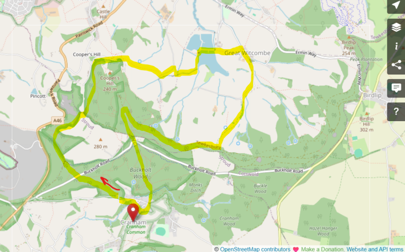
- Cranham is signposted off the A46. It's about a mile down the lanes. As you approach the village, downhill, you'll spot a small car parking area on your left at the entrance to Buckholt Woods, enough for a dozen cars at a squeeze and on rough, uneven ground. A small sign explains that you need to pay to park, using the RingGo app.
- Enter the beech woods - a national nature reserve - and bear left uphill. You'll immediately see a couple of broad paths, the one closest to the wooden fence is a bridlepath, and walkers should take the one slightly to the right of it. They both go to the same place - uphill to eventually break out onto a lane called Buckholt Road.
- Almost straight across is the continuation of the path, into more woodland, continuing uphill and straight ahead, before levelling off for a short section before joining the Cotswolds Way. Way markers galore from here, and likely some people!
- There's immediately a steep descent before more gentle walking through woodland, which becomes Upton Wood, then Coopers Hill Wood.
- After 1.4 miles from the start of the walk, you'll see that a Cotswold Way signposts strangely points directly up a steep bank. Ignore this, to continue on the lesser used path that runs straight ahead. (The CW way marker seems to be taking walkers to the top of Coopers Hill, whereas we're going to skirt around the side of it.)
- The path starts to curl around to the right, and soon emerges at the foot of Coopers Hill. A bench commemorates Steve Brain who won the cheese rolling race on this hill eighteen times!
- Continue onto the lane, called Green Street, and after a few hundred metres, where the road starts to bend right in front of a house, look for a farm gate into what feels like land belonging to the house on the lane. You can see another farm gate into a field diagonally across this narrow piece of land - that's the path. Views of the reservoirs in the distance - which is where we're heading.
- Once in the field, follow the field boundary on your right downhill to a kiss gate into the next field. From here, make a diagonal route to the bottom of this annoyingly undulating field. You'll eventually see a lane/driveway (to Coopers Hill Farm I believe), but the kiss gate onto it takes some time to reveal itself. There was plenty of evidence that livestock had recently enjoyed a very good feed in this field, but no sign of the cows themselves.
- Head to the left when you join the lane. There is a marked footpath (on the OS Map) straight across the field towards the hedge, but I couldn't see it. So I simply followed this lane for a short distance and turned right down a tractor path to the entrance into the next field, where a footpath marker I was looking for pointed straight across a lovely field of wheat. To the left-hand side of the field was the continuation of the tractor track, so as a good walking citizen I took this to land at the right place at the end of the field.
- Turn left on a track towards a derelict property, now with the first of the reservoirs on your right through the trees.
- These are called Witcombe Reservoirs, managed by Severn Trent, and open to the public for Trout fly fishing.
- Follow the path across the causeway between two of the reservoirs. The path takes you over a stile into a field and follows along the side of a fence on the left to a stile into the next field. The path is clear from here, across the field to the left-hand corner in front of a large red brick barn of Church Farm. Cross the stile, turn immediately left and after a few large strides, turn right onto the lane towards the Grade I Listed The Church of St Mary, Great Witcombe.
- The Church of St Mary's is more than a village church. It serves as the family chapel of the Hicks-Beach dynasty, owners of the Witcombe Estate for around 400 years. Their memorials inside the church chart generations of local landowners, MPs and statesmen, including Michael Hicks Beach, Chancellor of the Exchequer under Queen Victoria. It's a fascinating glimpse into the people who helped shape both Gloucestershire and national politics.
- Continue straight ahead along the lane, passing the characterful old School House 'The Villa' on your right. The lane passes a house called Churchill Cottage then winds up towards the gates of Witcombe House. Turn right here to follow a lane, with cottages and barns on your left-hand side and open fields to the right.
- At a house imaginatively called 'The Cottage', way markers point you through a gate into a field between the house and a barn. Follow the way markers from here - it's the start of the uphill journey away from the valley floor of the Witcombe Estate and back towards Buckholt Woods. You might meet some livestock in these fields, but they seem docile and have their attention focused on other matters.
- The uphill journey continues through 2 or 3 fields, sometimes steeply, before eventually rejoining the woodland footpath and the Cotswold Way. But this is now also the Gustav Holst Way too. Turn right for gentle, easy walking through the woods.
- After 0.5 miles, look for a path to the left. It takes you uphill, steeply at first, before a gentler uphill towards Buckholt Sawmills. (I passed a number of paths uphill off the Gustav Holst Way, some looked under used and over grown, so I recommend finding one that looks to be the most popular route of the day - they all head to the same place, the sawmills and then Buckholt Road).
- At the sawmills, follow the track to the left towards Buckholt House (where Holst's mother lived as a child) and turn left on Buckholt Road. There's a footpath on the other side of the road, opposite Woodland House, the neighbour of Buckholt House.
- It's easy downhill walking from here, with Holst way markers guiding the way the closer you get to Cranham. Emerge from woods onto Main Street in the village, and look for signs to The Black Horse, which will be no more than 50 metres away. If returning to your car, it'll be to the right on Main Street, leaving the village past the Old Post Office, with a short burst uphill to the car park.
Notes
Gustav Holst & Cranham
Gustav Holst’s name sounds as if it belongs to a Central European composer. In reality, he was born in Cheltenham in 1874, the son of a Gloucestershire musical family whose roots ran deep into the Cotswold hills.
His father, Adolph, was Latvian. His mother, Clara, grew up at Buckholt House, which still stands above Cranham on the ridge you cross on Buckholt Road on the way back to Cranham. Holst spent time in the village as a young man, staying at Midwinter Cottage — the house directly opposite the Black Horse — and no doubt absorbing the quiet, wooded landscape of the valley and a couple of pints at the pub.
It was during one of these stays that he composed the tune (not the words) to In the Bleak Midwinter, now one of the nation’s most favourite hymns and sung my congregations everywhere. The music was set to a poem by the English poet Christina Rossetti, first published in 1872. Once you’ve walked Cranham in winter fog, or watched rain sweep across the beechwoods, the melody makes perfect sense: it feels as if it was written for this valley.
The Gustav Holst Way, a 35‑mile waymarked trail from Cranham to Wych Rissington, traces the landscapes that shaped him. Much of it follows the Cotswold Way, which is why it doesn’t appear separately on OS maps — a kind of “ghost route” hiding in plain sight. Its official start is at Cranham Church, a mile from the village, where the walk begins its journey through the countryside that formed him.
Cheese Rolling at Cooper’s Hill
If you’re reading this from outside the UK you may assume that cheese rolling is something we invented recently to amuse tourists. It isn’t.
It’s an ancient, pagan‑tinged, gloriously unregulated tradition in which grown adults hurl themselves down a near‑vertical slope in pursuit of a runaway wheel of Double Gloucester cheese.
The slope in question is Cooper’s Hill, which you pass on this walk. On television it looks steep. In person it looks like the sort of incline you’d only descend if your brakes failed. The cheese is given a one‑second head start and reaches the bottom long before the humans do. The humans, for their part, reach the bottom in a variety of creative shapes.
There is even a memorial at the foot of the hill to Steve Brain, an 18‑time champion whose ashes were scattered on the slope at his request — a detail that tells you everything you need to know about the seriousness with which this “lunacy” is taken locally.
The event is technically unofficial, occasionally discouraged, and entirely unstoppable. It is English eccentricity at its most distilled: ancient, communal, mildly dangerous, and carried out with complete sincerity.