

The Pigs Nose Inn, East Prawle
Fabulous South West Coast Path walk around Devon’s most southerly tip at Prawle Point, 5.8 miles

Try this Pub & Walk
There's a question I get asked more than almost any other by people who know I spend time in this corner of South Devon: have you been to the Pigs Nose?
It's said not as small talk, but as a kind of password. The Pigs Nose Inn has that reputation you see. It's known by people who've never managed to get there yet.
And getting there requires determination, more so these days. East Prawle doesn't sit on the way to anywhere; it sits at the end of a tangle of high-banked lanes in the far southern corner of the South Hams, and this year the usual coast route main road that would launch you into those lanes is gone, at least from the east — Storm Ingrid took the A379 at Torcross, the so-called Slapton Line, clean into the sea back in the winter. The road remains closed, with no funded repair in sight. Anyone coming from the Dartmouth end of the A379 now has to swing inland through Halwell and approach via Kingsbridge instead, which makes an already remote village feel quieter still.
Even in normal years, East Prawle misses out on passing trade — there's no evening ferry across from Salcombe to East Portlemouth, so the cash-rich holiday crowd staying twenty minutes away as the crow flies rarely wanders this far after dark. This summer, with the direct coast road cut, East Prawle and its pub could be among the hardest hit villages in the area, precisely because a visit here has to be deliberate.
So head to the Pigs Nose and build a day around it.
Arriving on the green after the fiddly drive through the lanes, and finding walkers, campers, day-trippers and locals all converging on the same spot to lace up boots and check the weather, feels like arriving at a car park at the foot of a mountain track — the pub sitting there, ready for your return.
Put that alongside one of the best short sections of the South West Coast Path in Devon, and you have a genuine contender for one of the very best pub-and-walk combinations this site covers.
About The Pigs Nose, East Prawle


Last visit: June 2026
The Pigs Nose has stood on East Prawle's green for the better part of five hundred years, and has been a Victorian hotel, a smugglers' inn — used, by all accounts, to store the "booty" from the wrecks along this coast — and even a village petrol station when cars arrived in the village in the 50's, before settling into life as the pub it is today. The Webber family has run it for over 25 years: Peter and Lesley built its reputation, and their son Joss now steers where it goes next.
It's a business that's working hard on both ends of the calendar rather than just riding and relying on the summer wave. Next door, the Pigs Shack does pizza, burgers and a pint, with no booking required — useful when the main pub is stretched at peak season, and probably the more realistic option for the small campsites that spring up around the village every July and August. There's a small beach shop across the lane too, for anyone who's heading down to the sea.
And the hall next door, plus Pete's earlier career know-how, have built the Pig's Nose a reputation as Devon's most southerly live music venue. Its stage has seen Atomic Kitten, Lee Scratch Perry, Damon Albarn, The Animals, The Boomtown Rats and The Blockheads pass through a tiny, remote village most of them probably needed satnav to find, even though 'don't follow satnav' might sometimes be recommended.
But what stays with you isn't the music or shipwreck memorabilia, the Snog room (or was it Snug?), Otter Bitter from the barrel or the smell of pizza from next door.
It's regulars greeted the way only people who've genuinely missed each other's news are greeted — haven't seen you for ages, how are you doing, the usual? — the kind of warmth that only comes from staying open long enough, in the same small place, to earn it. And it's the walkers you passed on the coast path that morning with a nod and a comment on the weather, now drying out at the next table, the conversation picked back up properly over a pint.
That's the real case for the walk to the Pigs Nose: not just the wrecks off Prawle Point or the view from Gammon Point, but arriving somewhere at the end of it where people are actually glad to see each other — and happy to let you in on it too.
Pub Key Information
| WEBSITE | https://www.pigsnoseinn.co.uk/ |
| ADDRESS | The Pigs Nose Inn, East Prawle, Kingsbridge, Devon TQ7 2BY |
| PHONE | 01548 511209 |
| WHAT3WORDS | ///confident.pumps.honey |
| PARKING | No pub car park. There's parking around the village green. |
| LOCATION | East Prawle is the Southernmost tip of Devon, an area known as the South Hams. Kingsbridge is the nearest town. |
| HANDY FOR | This is a remote spot. The village is popular with walkers and handy for the South West Coast Path. The Gara Rock Hotel is to the west, and from there it's another mile or so down towards East Portlemouth and the passenger ferry to Salcombe. A good walk to the east will take you to Torcross and Slapton Sands. There's no public transport, but Kingsbridge taxis will run out to East Prawle via the A379. |
Walk Overview
East Prawle's name comes from the Anglo-Saxon Præwhyll — lookout hill — and people have kept watch from here longer than almost anywhere else in the county. Prawle Point, a short walk from the village, is Devon's most southerly tip, watched over since the Bronze Age and today staffed 365 days a year by the National Coastwatch Institution.
The circular route is around six miles with close to a thousand feet of climbing. Head west first and then onto the coast path near Gammon Head, one of the best views the whole walk offers. The stretch east to Prawle Point is just as good, and the lookout station is worth stopping at: a small history exhibition sits alongside it - the number of wrecks recorded up and down this stretch of coast is sobering.
Round the point, the path drops easily almost to sea level past the old watchkeeper's cottages, then roughens up again past Maelcombe House. It soon turns inland and climbs hard through the combe above Woodcombe Sand, before levelling out across the fields on the way back to the green — and the pub. It's tricky underfoot in places, more so in wind and rain, which down here is a fair bet on any given day. But few six-mile stretches of the coast path pack in as much: cliffs, wrecks, wildlife, a working lookout station, and a proper pub waiting at the end of it.


Walk Key Information
| START/FINISH | The Pigs Nose Inn, East Prawle, TQ7 2BY |
| PARKING | Around the village green, near the pub. |
| GRID REFERENCE | SX 781 364 |
| WHAT3WORDS | ///confident.pumps.honey |
| DISTANCE/TIME | 5.8 miles / 9.3 km; approx 3 hours |
| ASCENT | 960 feet / 300 metres |
| PATHS/TERRAIN | Some tarmac walking along quiet lanes to start, then onto stony bridleways and grass tracks to the coast path. Narrow but perfectly safe footpaths from here, sometimes over tricky rocky ground. Some field walking on the return might encounter docile cattle. Some gates. |
| DIFFICULTY | Moderate |
| PUBLIC TRANSPORT | None |
| TOILETS | Public convenience on the green at East Prawle. Toilets at The Pigs Nose Inn. |
| OTHER PUBS TO VISIT | Gara Rock Hotel along the coast to the West has a wonderful bar on the terrace high above the sea. Other pubs are well worth seeking out: The Millbrook Inn at South Pool; The Cricket Inn at Beesands; The Tradesmans Arms at Stokenham; The Bear and Blacksmith at Chillington; and the Start Bay Inn at Torcross. When the Slapton Line re-opens, The Tower Inn at Slapton is superb. |
Walk Instructions: Choose what works for you
There are multiple ways to consume the route described below.
- Either follow the online Walk Directions below, or download and print a copy of the route.
- If you have the OS Maps App, you can follow a saved route directly in the OS App.
- Or download the GPX file for use with your chosen GPS-based tracker App, like Strava. Upload the file when you Create a New Route in the App.

Walk Directions
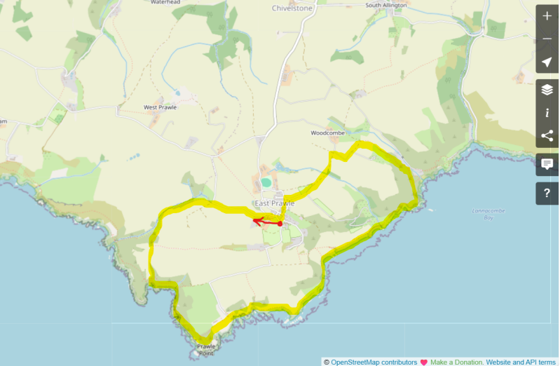
- The walk starts at the village green in East Prawle. Set off on the road with the Public Toilets on your left, heading out of the village, likely via the narrow road into the village upon which you arrived. Passing houses, the road bends to the left before passing a long stone building on the left, which runs all the way up to a junction on the left-hand side at a bend.
- Turn left here, past properties called Winter Hill and The Retreat. Follow this lane until it bends to the right, and here continue straight ahead onto a public bridleway, a stony track. The route is clear from here.
- Pass through a gate and continue straight ahead, joining a grassy track slightly and the first sea views of this walk – Bolt Head at the entrance to the sheltered harbour of Salcombe.
- Pass through a wooden gate, continuing uphill on a ‘hedge path’ to a footpath junction. Take a moment to sit at Josephine’s Bench. One of the landmarks on the cliffs to the right is called Pig’s Nose, annotated on OS Maps.
- From your seat on the bench, our route to the coast path is straight downhill between hedges directly in front of the bench.
- As you approach the coast path at the footpath marker above the coast, turn right for a short distance to join the coast path. Take a moment to enjoy views of Elender Cove and Gammon Head.
- Now follow the coast path to the left (East) to make your way to Prawle Point and the lookout station. There are some fascinating insights into the history of shipwrecks on this coast, and why the work of the National Coastwatch team is so important.
- Continue on the coast path in the direction of the coastguard cottages, and downhill towards sea level on a grassy path in fields. Beyond the houses a path leads back into East Prawle, for those who wish to hasten the visit to the Pigs Nose!
- The coast path is clearly marked, and relatively easy walking at low level. Some of the markers will guide you towards Lannacombe – that’s the correct direction, although we’re not going that far. Some sections of the path from here are narrow, with undergrowth on either side – ingredients for wet trousers and footwear after rain.
- You’ll notice a distinctively large property you’re walking towards, called Maelcombe House. The path eventually passes in front of this on its way to Stinking Cove, and soon requires some caution as it continues over rocks that require concentration and careful placement of feet.
- The path then turns away from the coast a little and starts uphill to a footpath signpost for Woodcombe Sand. Go straight on here, to start the climb up the combe away from the coast path.
- Over a shaded footbridge ignore the sign for Lannacombe now, instead following the path in the direction of East Prawle 1.5 miles away. This steep path took some effort on a hot day, but at least offered welcome shade.
- Reaching a bridleway junction at the top of the combe, go left and eventually through a gate onto a lane. Continue ahead.
- The lane turns 90 degrees right, then as it turns again, follow a footpath 90 degrees to your left into a field, to follow the hedge-line with the hedge itself on your right. Plenty of cattle in this field when I visited, completed disinterested in me.
- After leaving the field, continue ahead on a farm track towards the road to East Prawle. Join a tarmac road now, a quiet lane into the village. Head left downhill through the village, and left at a junction.
Other Pubs to try in Devon

Salcombe to East Portlemouth circular, via Ferry & the South West Coast Path.
3.8 miles

Slapton Ley Nature Reserve & the Slapton Sands D-Day Memorial.
3 miles

Bigbury-on-Sea to Ringmore & Aylmer Cove, South West Coast Path loop
4 miles